|
|
||||
|
Letter to Erie Board of Trustees |
Dear Members of the Town of Erie Board of Trustees, It is an honor to make this submission to you and I am pleased to have the opportunity to work with each of you, the members of the Erie Planning Commission, and the Town's staff regarding the exciting opportunity presented by the annexation of our property to the Town of Erie. As you know, developers and builders have been approaching us for years and we have resisted many offers. Unlike many other properties, ours has been in the Erie Comprehensive Plan and has been slated for development for decades - with it most recently being included as land to be annexed to Erie according to the terms of the 1994 Intergovernmental Agreement between Erie, Lafayette, and Boulder County. With Erie growing steadily over the past several years and with many controversial issues raised this past year, we felt the time was right to formally become part of the Town and to try and do so in a manner which benefits the broader community. With all the discussion and debate regarding "Growth," we hope our proposal can make a positive contribution to that discussion and to the concept that Managed Growth and Controlled Growth, if done "right," can be good for the entire Erie community. Here are some of our personal thoughts, some of the steps we have taken which are different from others, and some of the objectives which are critical elements of our plan. * PERSONAL PERSPECTIVE. We know our perspective differs from those who are professionally involved in development for a number of reasons. First, we live in the Erie community and plan to be here for the rest of our lives. What happens to our property and to Erie is going to be more important to us than to a developer or builder who wants to quickly build and sell as many lots and homes as possible and then move on to the next project - whether that be in Erie or, more likely, elsewhere. We are not criticizing developers. That is the business they are in. However, it is not our business. Second, we actually live on our property and have attended to it for a number of years. We care passionately about the kind and quality of development which will surround us and care far more than any absentee developer or builder. We are here to stay. Third, because we are in it for the long-term, we want to do what's best for the Town. That means taking our time to find the best people "to do it right." This also is why we appreciate the long-term nature of our relationship with you. Fourth, we understand that maintaining control over the project means we cannot sell everything to a developer. This means we may incur much greater financial risks. Nevertheless, by ensuring that high standards are met, we will realize far more meaningful rewards - i.e., the creation of a quality project and a contribution to the further formation of a long tradition of creating "community" in Erie. * THE TEAM. We have
put together an exciting group of people to create our plan. They are
professionals with a different perspective on growth. They seek ways to
achieve designs which are aesthetic, environmentally-sound, and compatible
with the area. They are sensitive to special needs and look at this project
as an opportunity for everyone. They have great latitude creatively because
I am not a developer or builder. That is a huge advantage. While developers
and builders are forced to consider everything from a financial perspective
and have to move from one project to the next, that isn't the case here.
We can do what truly is best for everyone. We can make decisions which
result in a higher aesthetic component. We can strive for much higher
quality. We can and want "to do it right." * SPECIAL DESIGN APPROACH. I have asked the Golden Run Team to consider how the look of Old Town Erie could be integrated into the project. This might mean doing something as obvious as constructing buildings which are a reflection of Old Town Erie (such as an elementary school using the Lincoln School exterior as a model) as well as planning links and trails into Old Town Erie and other parts of town. We would like to see permanent residents and people working on-site at Golden Run regularly walking and bicycling into Old Town for lunch or to shop. The specific features of the property, key design elements and our vision for the future all will create a unique project in Erie which will be a credit to Erie's imaginative and leading-edge approach. Our goal is to help people across Colorado and around the country see Erie as a community which is solving problems related to growth in a creative and effective manner. We also want developers and builders to see it is financially possible "to do the right thing." * NEW URBANISM. We have tried to select the best New Urbanism has to offer and tailor it for Erie and this particular site. Using a more compact planning approach will save money on utilities and create a greater sense of neighborhood. It also provides the opportunity to create more open space and not block Front Range backdrop view corridors. With New Urbanism's mixed use approach and range of building options, people can work, shop, and play closer to where they sleep, and often do these activities without their cars. New Urbanism is an alternative to "Urban Sprawl." Through better land use and design, we can create a human-scale place to live, where buildings and streets relate to each other in ways which encourage people to experience them on foot. This plan is for people - not cars. By having homes close to services (such as offices, retail, and transit), we can achieve a much livelier mix of uses which promotes social interaction. New Urbanism also exchanges smaller lot sizes for more parks, open spaces, and other green spaces. This allows the land to not be so cluttered. If you look at many developments done over the past few decades, lots are allocated and housing is constructed so there are few "green areas." In these instances, the land almost is completely covered up with houses and streets, with little else left. New Urbanism counters this with a much more humane approach and a livelier design. Varying the sizes of both lots and buildings, organizing streets with a hierarchy of scale, and providing landmarks are just some of the tools New Urbanism employs. New Urbanist designs strive to create a "sense of place." Our Plan is designed using both historical and new tools so the result is a place which is vital, active, and ecologically sound. The ultimate goal is to provide a happier, healthier place to live. * LOCATION. The site already is surrounded by the Town and is an obvious fit. This was why the property was included in the Erie Influence Area and anticipated for annexation in the 1994 Intergovernmental Agreement signed by the Town of Erie, the City of Lafayette, and Boulder County. To the east is property all of which has been annexed to Erie. It is zoned for commercial and light industrial uses (it is one-half mile in length). The same applies to the eastern half of the southern border (also one-half mile in length). The entire northern border (one mile long) is the Canyon Creek subdivision, which already is under construction. To the west (a one-half mile border) are homes built on large-sized lots in unincorporated Boulder County. Back to the southern border, on its western half (one-half mile in length) is Boulder County Open Space. Overall, this means that about two thirds of the property borders the Town - far in excess of the 16% minimum requirement for annexation and another indication of the "fit" of the property. The property is part of Erie's "Southwestern Gateway" in that North 119th Street accommodates a large number of people coming into Town. With Leon Wurl Parkway now open, North 119th Street will become a major route to Old Town Erie and to I-25. As a result, we have designed the western side of the project to make it more attractive for people driving by and for those living in the area. The same aesthetic objectives apply to County Line Road, as our conceptual plan shows. Our goal is to have people enter Erie at our border and be impressed with what they see. Finally, the property also is a natural fit from the perspective of law enforcement - with its annexation providing a half mile of inclusion on each of North 119th Street and County Line Road. This closes the current gap between annexed properties which are part of Erie but which, today, are separated by stretches of unannexed land.. * SPECIAL AREAS. From
a personal perspective, our goal is to maximize the "green areas"
within the property. This means saving the Pond and expanding the wildlife
area we have developed around it over the past decade. * DENSITIES. The project's density compares favorably to the Canyon Creek subdivision across our entire one-mile northern border yet provides over 300% more open space and green areas. The density has been the subject of discussion with Town staff for some time and has been lowered significantly from what was originally contemplated . It is consistent with the Comprehensive Plan and is minimally adequate to help create the "critical mass" needed for some of the anticipated commercial activity. That activity now also depends on residential development elsewhere but, because such development already is scheduled to happen, the lower densities on the site should be marginally sufficient. The site has long been designated for "Primary Urban Density" development and should continue to be viewed as a component of the critical mass Erie is seeking, especially to anchor Downtown. We will offer a very wide range of housing and commercial spaces. While apartments can be used to create more opportunities for parks and open space, they cannot entirely replace the single-family housing element which is critically important. With clustering and by using smaller lots, desired densities can be obtained while increasing the amount of land preserved for parks, open spaces, and green areas. For this reason, "units-per-acre" calculations can be misleading. The real questions ought to be "What are we getting" and "What kind of communities will this design help us build?" By using compact designs and by clustering housing, this approach can maintain densities yet provide maximum open space and other green space. We hope you will agree that our innovative approach is exactly what Erie needs today. * SPECIFIC ENVIRONMENTAL CONSIDERATIONS. Golden Run could help define what a truly "green" project is all about. Land-shaping design, siting of homes for maximum solar gain (to reduce utility usage), special building designs, and overall planning are very important but we would like to take the next steps to a higher level. A community designed with recycling in mind (with community composting and recycling centers), with wastewater reduction and gray water systems as part of the original plan, with a unique wildlife habitat created from what was a man-made irrigation pond, with alternative and green building materials encouraged, and with community gardens for all to participate in and enjoy, all are significant features we would like to see incorporated into final designs. Having "green areas" which include open spaces, parks, tot lots, streetscapes, special landscaping, and similar viewing areas which are triple the size of what normally is expected also are goals we have. Reducing traffic and car usage by allowing live/work units and creating on-site employment opportunities are important design elements, too. * COMMERCIAL OPPORTUNITIES, AND BUSINESS INCUBATION. The plan offers four concrete ways to promote economic activity. First, we have a substantial commercial/employment area for the property. It totals over one million square feet - right in sync with the Comprehensive Plan. Second, we are encouraging "work/live" opportunities to allow some limited living spaces above or next to small businesses. This will create opportunities for people to live near their places of work and can serve to reduce traffic. Third, we are incorporating reasonable work-at-home regulations to accommodate telecommuters and others who want to start small businesses at home. Fourth, we will incorporate sensible, limited commercial activity within the borders of residential developments. This will create more of a neighborhood "feel" and also will help reduce traffic by allowing residents to walk to neighborhood stores and shops. The combination of these four factors should make the site a "business incubator" for the entire Town of Erie by providing opportunities for start up and expand small businesses as well as for well-established firms. We look forward to working closely with Erie's Director of Economic Development, Ernie Witucki, and are especially interested in projects which coordinate the commercial and retail efforts of Golden Run and its neighbors. * SENIOR FOCUS. As the
name of the project connotes, we want Golden Run to be seen as a "mature-adult
friendly" environment which offers a full range of housing and life-style
options to people 50 and over. This is attractive to many of us as we
reach that age ourselves or who already have elderly parents who want
to become or remain part of the community. These are needs in the broader
community we can help meet. Our mixed use approach provides for single
people, young families, middle-aged folks, seniors, empty-nesters, and
those needing independent living facilities and even higher levels of
care. With such a mix, we can help keep families together so they can
stay in touch and be involved with each other for entire lifetimes. Our
plan for large open spaces and lots of small parks - within easy walking
distance of everyone - also accommodates those who cannot go too far but
want to remain active. In addition, our main retail sites and satellite
sites will provide easy access to services for everyone. * CIVIC SITES. We are prepared to designate both a Park site and a Civic site as a benefit to the entire community. This is in addition to our plan to maximize "green" or open spaces. While our discussions with Town staff have involved using the Civic site for an elementary school, we want you to know we also are willing to consider it as a site for a Senior Center or other community facility. It is possible that a school may not be necessary, especially with another elementary school being built across North 119th Street. This could make other civic uses more attractive. * RESIDENTIAL BUILDING OPTIONS. To avoid the "cookie cutter" approach used by others, Golden Run is being designed with flexible building and zoning standards which encourage mixed uses and creative solutions for a variety of housing needs. Golden Run will add to Erie's diversity because it will not look like most developments. Housing types will include studio apartments over small retail outlets, live/work efficiency units, a mix of residential and accessory units, townhomes, patio homes, "empty-nester" homes, apartments and condominiums of all sizes, duplex and triplex units, co-housing (with an emphasis on seniors' needs) and other diverse senior housing, and there certainly will be traditional single-family homes but with a wide variety of shapes, sizes, designs, and prices. This diversity will provide accessibility for younger families as well as for our older citizens while better accommodating the needs of people at all the different stages of their lives. No one will be left out. Golden Run will look like part of a town which developed over the course of several decades, beginning at the turn of the century and will appear similar to a return to "The Good Old Days" but with modern amenities and higher standards throughout. * COMMERCIAL BUILDING OPTIONS. Commercial and employment building designs will address a wide range of needs. The variety of types will be expanded from a traditional set to make the offerings and final designs more attractive. The space totals will exceed those contemplated in the Comprehensive Plan by only three percent but could be adjusted upwards, based on demand. Smaller business opportunities may exist throughout the project but the majority of activity will be concentrated in the eastern third of the property where a "walkable" commercial Village Center is contemplated. The range of offerings will be made large enough to accommodate the small businessperson just starting a venture all the way to prospective large corporate tenants. We are especially sensitive to accommodating the high technology needs of all businesses and will be working directly with providers to ensure the site is developed with the most advanced telecommunications infrastructure possible as an special attraction. * PROCESS AND PUBLIC ACCESS. We have decided to improve and try to help set a new standard for public access by placing our entire initial application on the Internet (it will be located at www.GoldenRun.com). We hope to accomplish this within the next four weeks. By being on-line, we can enable any citizen to review the documents we have created at his or her convenience and at no cost. By making everything available for free on a 24-hour-a-day basis, we believe we will achieve a degree of openness and disclosure unheard of prior to this effort. Well before even submitting our proposal, we held discussions with Town staff, with many of our neighbors, and with some of Erie's most vocal growth control proponents. We have been thanked for this outreach effort. Our proposal has been modified based on the suggestions we received. For example, the Town staff had us lower our total unit numbers, the neighbors encouraged us to emphasize our buffers, and the growth opponents helped us understand that, by doing something different, this annexation could benefit the entire community. We believe we will receive the endorsement of Town staff, assistance from most of our neighbors, and even support from some people recognized solely as growth control proponents. We plan to continue to hold "town hall" meetings throughout the project's life. We also have tried to complete everything at the beginning of the process - including a draft Annexation Agreement - so the Town would have as comprehensive a package as possible. We hope this helps expedite the approval process. After many years of thought, we are excited about the potential this project offers everyone. We recognize that our relationship with you is a long-term partnership. We look forward to working with each of you. Always feel free to contact me at (303) 666-6161 or via e-mail (aaron@goldenrun.com). As you can imagine, for a number of reasons, we can't wait to change our address from "Lafayette" to "Erie." Thank you very much for your time and consideration. Respectfully yours, |
|
Narrative
Description
|
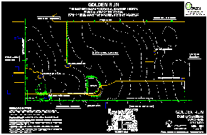
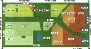
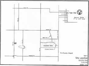
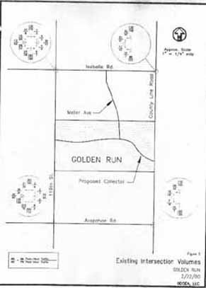
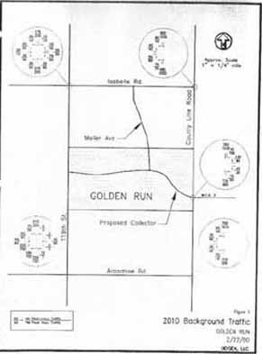
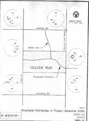
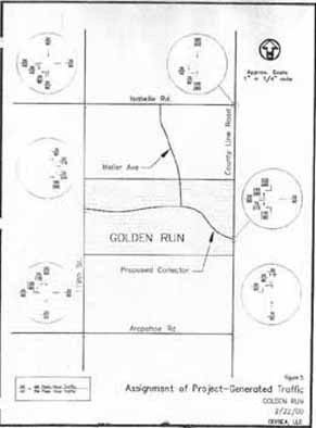
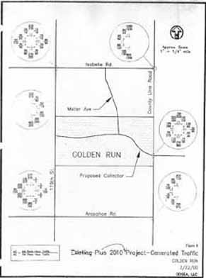
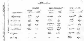
NARRATIVE DESCRIPTION Introduction Golden Run will be a 330-acre development that will include a healthy diversity of land uses. In order to convey the intent of the following narratives, it is necessary to describe some underlying principles that are driving the Conceptual Plan. Providing a human-scale, usable environment for the occupants of this development is paramount, along with a need to reduce the environmental impact of its services and uses. With these goals in mind, Golden Run will be planned with the pedestrian and Old Town character of Erie as driving forces. Golden Run intends to organize the development into neighborhoods, district, and corridors. Neighborhoods are areas with a balanced mix of human activity; districts are areas dominated by a single activity; corridors are connectors and separators of neighborhoods and districts. The proximity and scale of these elements will be determined by their intended level of activity and public safety. New Urbanism and "green" development principles will be employed to create a place that will not only be enjoyable for the community to use, but will enhance the regional character and link together the various land uses adjacent to this property. Street Master Plan The proposed development will connect to County Line Road on the east, North 119th Street on the west, Meller Street to the north, a local street to the north and a local street to the south. A Major Residential/Business Collector will be placed inside the development, running east-west, acting as a collector for all internal lot access. No direct access from an individual lot will be allowed onto County Line Road, North 119th or within the development onto the proposed collectors. Both County Line Road and North 119th Streets function as arterials. Pedestrian and bicycle trail systems will connect open space, transportation corridors and commerce to existing town facilities and to Old Town Erie as shown in the Comprehensive Plan. Trails will be located off-street when possible. A separation of automobiles and pedestrians is viewed as safe and aesthetically pleasing, however portions of the trail network will require use of the planned streets within the development. Street standards will accommodate both pedestrians and bicycles. A pedestrian underpass is planned near the intersection of Meller Street and the main collector running east-west, under the collector, in order to safely connect children and open space users from the northern half of the property to the southern half. Subdivision Plan The Conceptual Plan shows a mix of uses within the proposed development. Along the eastern property boundary is located the central commercial district. This location is also intended as a transit center for the community. As traffic increases along County Line Road, it is very likely that bus service will be provided along this corridor. Moving west from County Line Road, immediately west of the commercial district, mixed-use facilities will be allowed, including live-work units, attached residential units to office and retail facilities, commercial "incubator" units, light industrial and higher density attached residential dwelling units. These uses will be immediately adjacent to the commercial district and will blend into lower density residential units to the west. Moving further west, a civic site including an elementary school and/or library and community park abut the northern property line between the two road connections to the north. Across the main collector, is another park linking open space to the south. Open space around the existing pond is planned as natural habitat buffer. Further west to the western property line is medium and lower density detached residential uses intermixed with interior parks and open space. Planned densities within the development accommodate the clustering of dwelling units, allowing for more open space. The main collector is planned within a wide open space corridor, creating a long park for use by area residents, and a bike/pedestrian path meandering along its length. A central pond or fountain will be placed as a design focal point for all of the activity on this site. Deviations from existing Town subdivision standards include reducing setbacks on a portion or all of the units to accommodate a more usable backyard, garages and carriage houses. Building facades located closer to the street provide a more friendly environment for pedestrian use and increase perceived safety of the neighborhood. Tree-lined streets with buildings located closer to the street will also contribute to slower traffic speeds, further enhancing the safety of the neighborhood and better reflecting the character of Old Town Erie. Comprehensive Plan The Erie Comprehensive Plan land use map (1999) designates this property for both Urban Density Residential and Employment development. Golden Run is proposing a PD (" Planned Development") zoning which allows it to comply with the intent of the Zoning Ordinance, using "innovative and creative design and to facilitate a mix of use…". Golden Run is proposing a gross density of approximately 2.4 dwelling units/acre, on the entire 330+ acres. These dwelling units are within 252.7 acres of residential zoning and open space. 43.8 acres will be zoned as exclusively commercial and will accommodate approximately 956,000 square feet of commercial retail, office and light industrial uses compatible with mixed-use development. The total area of open space within this development will be 40% of the 330 acres. By clustering the developed zones, Golden Run is able to create more open space for public use than surrounding developments. By strategically locating these open spaces and linking them together with pedestrian corridors, Golden Run is able to connect the surrounding land uses in an efficient and environmentally sensitive manner. The commercial sector is planned to accommodate the same level of activity as indicated in the Comprehensive Plan. The Comprehensive Plan indicates approximately 110 acres of "employment" area. Using DRDOG ratios of building to land (approximately 20%), we estimated 956,000 sf of commercial space. This commercial space is spread across 43.8 acres of purely commercial and 19.1 acres of mixed-use zoning. By densify-ing the commercial sector, the activity on the site will be at a human scale that is walk-able, not dominated by parking lots and unusable land. The area of open space typically found in commercial development has been rolled into the other open space areas on the site to create meaningful common areas, both within and around the commercial zones. It appears to be smaller in size than the 100+ acres originally zoned as "employment." However, the amount of commercial square footage proposed is in line with the original 100+ acre allotment, only in a smaller, more efficiently designed space. Open space originally designated as a requirement within the commercial district has been incorporated into the overall development plan to provide community-wide opportunities that are consistent with a mixed-use, pedestrian oriented development. Existing and Adjacent Land Uses Presently, there are a variety of adjacent land uses. The subdivision of Canyon Creek to the north is planned as a detached residential subdivision with lots not exceeding 9000 square feet. To the west, across North 119th Street on the northern half of Golden Run property line is the Price Annexation. This subdivision will be similar to Canyon Creek with primarily detached units. Along the southern half of the western boundary across North 119th Street are larger lots already subdivided and developed which are in Boulder County. To the South, along the western half of the property is Boulder County Open Space. The eastern half of the southern property line is the Young Annexation, zoned as "employment," identical to Golden Run's zoning along County Line Road. To the east is the Feuer property, which is also zoned as "employment." The existing land use of this property is predominantly agricultural production in the form of small grains. There are four residence on the property, with the land owners residing in the primary one on the western end. In addition, there are two minimal producing gas wells, one on each half of the property. Proposed Development Staging
and Time Frame Larger commercial anchors, such as major employers, may develop as soon as 2006. |
|
Land Use
Application
|
| Project No. _______________Fees Paid $ __________ Receipt No._______________ ALL APPLICANTS: REQUEST: X Annexation Preapplication
Preliminary Pint Final Plat Location (attach full legal description): See attached legal description, Exhibit A DESCRIPTION OF REQUEST (Attach
additional pages if necessary): Annexation and zoning of attached described
property into the Town of Erie to be zoned "PD" per the Zoning
Ordinance in use at the time of this application. AUTHORIZED REPRESENTATIVE: Golden Run, LLC MAILING ADDRESS: 2500 North 119th St., Lafayette, CO 80026
Gross Site Acreage: 330.49 Gross Site Density: 2.4 du/ac Square Footage Proposed on Non-Residential Development: 956,000 Present Zoning: Agriculture (BOCO) Proposed Zoning: PD Mineral Rights Owner: Aaron
Harber 2500 North 119th Street, Lafayette, CO 80026 Union Pacific Resources Co.
Post Office Box 7, Ft. Worth, TX 76101 Water Rights Owner: Aaron Harber 2500 North 119th Street, Lafayette, CO 80026 (name) (mailing address) The undersigned is fully aware
of the request/proposal being made and the actions being initiated on
the referenced property. The undersigned understand that the application
must be found to be complete by the Town of Erie before he request can
be officially accepted and the review process initiated. The undersigned
is aware that the applicant is fully responsible for all reasonable costs
associated with the Owner: Date: Applicant: Date:
Witness My hand and official seal. Notary Public |
|
Letter
of Authorization
|
AARON HARBER 2500 North 119th Avenue Lafayette, CO 80026-9216 February 25, 2000 The Honorable Victor Smith,
Mayor Re: Golden Run Annexation Dear Mayor Smith and Members of the Board of Trustees, As owner of approximately 320 acres of property generally located between County Line Road and 119th Avenue immediately south of the Canyon Creek subdivision, more specifically described in the attached annexation petition and proposed annexation agreement, I hereby authorize Golden Run, LLC, a Colorado Limited Liability Corporation, to represent me in applying for annexation to the Town of Erie pursuant to Colorado law and Erie's zoning ordinance. Thank you for your consideration of the materials enclosed herewith. Sincerely, Aaron Harber cc: Carl Oldham, General Manager, Golden Run, LLC |
|
Letter
of Intent
|
GOLDEN RUN, LLC a Colorado Limited Liability Company 4770 Baseline Road, Suite 200 Boulder, CO 80303 February 25, 2000 The Honorable Victor Smith,
Mayor Re: Golden Run Annexation Dear Mayor Smith and Members of the Board of Trustees, As the duly authorized representative of the owner of approximately 320 acres of property generally located between County Line Road and 119th Avenue immediately south of the Canyon Creek subdivision, more specifically described in the attached annexation petition and proposed annexation agreement, I hereby express our interest and intent to annex this property to the Town of Erie pursuant to Colorado law and Erie's zoning ordinance for residential, retail, office and mixed use development. We look forward to working with the Town in processing this request. Sincerely, Carl J. Oldham cc: Aaron Harber |
|
Annexation
Petition & Agreement
|
TO: THE BOARD OF TRUSTEES OF THE TOWN OF ERIE, COLORADO. RE: Petition Known As: Golden Run DATE: February 25, 2000 I, Aaron Harber , the undersigned landowner, in accordance with Colorado law, hereby petition the Town of Erie and its Board of Trustees for annexation to the Town of Erie of the following described unincorporated territory located in the County of Boulder and State of Colorado, to-wit: "See legal description in Exhibit A, attached hereto and incorporated herein by this reference." As part of this petition, your petitioner further states to the Board of Trustees of Erie, Colorado, that: 1. It is desirable and necessary that the territory described in Exhibit A be annexed to the Town of Erie. 2. The requirements of C.R.S. sections 31-12-104 and 31-12-105, as amended, exist or have been met in that: a. Not less than one-sixth of the perimeter of the area proposed to be annexed is contiguous with the Town of Erie or will be contiguous with the Town of Erie within such time as required by 31-12-104. b. A community of interest exists between the area proposed to be annexed and the Town of Erie. c. The area proposed to be annexed is urban or will be urbanized in the near future. d. The area proposed to be annexed is integrated with or is capable of being integrated with the Town of Erie. e. No land within the boundary of the territory proposed to be annexed which is held in identical ownership, whether consisting of one tract or parcel of real estate or two or more contiguous tracts or parcels of real estate, has been divided into separate parts or parcels without the written consent of the landowner or landowners thereof, unless such tracts or parcels were separated by a dedicated street, road or other public way. f. No land within the boundary of the area proposed to be annexed which is held in identical ownership, comprises twenty acres or more, and which, together with the buildings and improvements situated thereon has an assessed value in excess of two hundred thousand dollars ($200,000.00) for ad valorem tax purposes for the year next preceding the annexation, has been included within the area proposed to be annexed without the written consent of the landowner or landowners. g. No annexation proceedings have been commenced for any portion of the territory proposed to be annexed for the annexation of such territory to another municipality. h. The annexation of the territory proposed to be annexed will not result in the detachment of area from any school district. i. The annexation of the territory proposed to be annexed will not have the effect of extending the boundary of the Town of Erie more than three miles in any direction from any point of the boundary of the Town of Erie in any one year. j. Prior to completion of the annexation of the territory proposed to be annexed, the Town of Erie will have in place a plan for that area, which generally describes the proposed: Location, character, and extent of streets, subways, bridges, waterways, waterfronts, parkways, playgrounds, squares, parks, aviation fields, other public ways, grounds, open spaces, public utilities, and terminals for water, light, sanitation, transportation, and power to be provided by the Town of Erie; and the proposed land uses for the area; such plan to be updated at least once annually. k. In establishing the boundary of the territory proposed to be annexed, if a portion of a platted street or alley is to be annexed, the entire width of the street or alley has been included within the territory to be annexed. The Town of Erie will not deny reasonable access to any landowners, owners of any easement, or the owners of any franchise adjoining any platted street or alley which is to be annexed to the Town of Erie but is not bounded on both sides by the Town of Erie. 3. The owners of more than fifty percent of the area proposed to be annexed, exclusive of dedicated streets and alleys, have signed this petition and hereby petition for annexation of such territory. 4. Accompanying this petition are four copies of an annexation map containing the following information: a. A written legal description of the boundaries of the area proposed to be annexed; b. A map showing the boundary or the area proposed to be annexed, said map prepared and containing the seal of a registered engineer; c. Within the annexation boundary map, a showing of the location of each ownership tract in unplatted land and, if part or all of the area is platted, the boundaries and the plat numbers of plots or of lots and blocks; d. Next to the boundary of the area proposed to be annexed, a drawing of the contiguous boundary of the Town of Erie and the contiguous boundary of any other municipality abutting the area proposed to be annexed, and a showing of the dimensions of such contiguous boundaries.
6. The zoning classification requested for the area proposed to be annexed is Planned Development . WHEREFORE, the following petitioner respectfully requests that the Town of Erie, acting through its Board of Trustees, approve the annexation of the area proposed to be annexed. By this acknowledgment, the undersigned hereby certify that the above information is complete and true. Owner: Date: GOLDEN RUN, LLC (Applicant) By: Date: STATE OF COLORADO) The foregoing instrument was acknowledged before me this day of , 19 by . My commission expires:
STATE OF COLORADO)
STATE OF COLORADO ) The foregoing instrument was acknowledged before me this day of , 19 by . My commission expires: (Insert the complete legal description of the property)GOLDEN RUN ANNEXATION AGREEMENT THIS AGREEMENT is made and entered into this ___ day of ________, by and between Golden Run, LLC, a Colorado Limited Liability Corporation , hereinafter referred to as the "Owner," and the Town of Erie, a municipal corporation of the State of Colorado, hereinafter referred to as "Erie" or "Town". WITNESSETH: WHEREAS, the Owner desires to annex to Erie the property more particularly described on Exhibit "A," which is attached hereto, incorporated herein, and made a part hereof (such property is hereinafter referred to as "the Property"); and WHEREAS, Owner has executed a petition to annex the Property, a copy of which petition is attached hereto as Exhibit "B," and incorporated herein and made a part hereof; and WHEREAS, it is to the mutual benefit of the parties hereto to enter into the following Agreement; and WHEREAS, Owner acknowledges that upon annexation, the Property will be subject to all ordinances, resolutions, and other regulations of the Town of Erie, as they may be amended from time to time; and WHEREAS, Owner acknowledges that the need for conveyances and dedication of certain property, including but not limited to property for streets, rights-of-way and easements, parks and open space, utility facilities and improvements, to Erie as contemplated in this Agreement are directly related to and generated by the development intended to occur within the Property and that no taking thereby will occur requiring any compensation. NOW, THEREFORE, in consideration of the above premises and the covenants as hereinafter set forth, it is agreed by and between the parties as follows: I. ANNEXATION AND ZONING. The annexation of the Property shall be in conformance with the Colorado Municipal Annexation Act of 1965, as amended, and with applicable Town of Erie codes. The Owner desires Planned Development District zoning, in accordance with the Erie Zoning Code (Ordinance 408). The parties recognize that it is the intent and desire of the Owner to develop the Property in a manner generally consistent with the zoning requested and that the granting of such zoning by the Town of Erie is a condition to annex the Property. Owner shall take all action necessary to permit zoning by the Town of Erie of the annexed area within the time prescribed by state statutes. A. Land Use. All residential and commercial construction will be subject to the types and intensities of land use permitted pursuant to the Planned Development Standards adopted herewith, attached hereto as Exhibit F, or for uses and densities not specifically addressed therein, pursuant to the Erie Zoning Code in effect on the date hereof. A. Master Development Plan. Erie and the Owner recognize that property development is subject to market conditions. To assure Erie that the development of the Property proceeds in an orderly manner, Owner may phase the development. A "master development plan" for the Property will be provided during the subdivision process. For each phase, a site specific plan will be submitted to the Erie Planning and Zoning Commission and the Board of Trustees for review and approval, which approval shall not unreasonably be withheld. The site specific plan shall be in general conformance with the "master development plan" for the Property, as approved and/or amended by the Board of Trustees. I. ANNEXATION MASTER PLAN FOR PROPERTY. The Erie Comprehensive plan encompasses the entire Property. The Comprehensive Plan does not set out in detail the land uses for the Property. The "annexation master plan" incorporated and adopted as a portion of the ordinance annexing the Property and attached hereto as "Exhibit C" complies with the requirements of C.R.S. §31-12-105 (1)(e). I. LAND DEDICATION. The dedication of parks and open space, public easements for utilities, rights-of-way for streets and other public ways and dedications for other public purposes shall be by Quit Claim Deed or appropriate instrument of conveyance acceptable to the Town. Dedications of public easements for utilities, rights-of-way for streets and other public ways shall occur immediately upon request of the Town except that internal rights-of-way shall be dedicated at the time of subdivision platting. The Town and the Owner agree that dedications of public easements for utilities, rights-of-way for streets and other public ways are directly related to and generated by development intended to occur within the Property and that no taking thereby will occur requiring any compensation. The dedication of parks and open space in excess of the minimum dedication offered below is a gift to the people of Erie and to future residents of the Golden Run development offered by the Owner in good faith and without an expectation that annexation approval is or may be conditioned thereon. A. Parks And Open Space. The Owner agrees to either dedicate to the Town of Erie, a minimum of 20 acres (6.25%) of the total acreage of the Property as public land, or to pay an equivalent "cash in lieu of" to the Town based on the undeveloped price of such land, or any combination of land and cash as is negotiated and agreed upon by the Owner and the Town. Any open space, parks, landscaped right-of-ways, or trails dedicated to the Town may count towards the land dedication. The dedication of land or cash in lieu of land is at the Town's option and discretion. A. Roads And Utility Easements. The Owner shall dedicate right-of-way for all roads and utility easements to Erie. All utility easements dedicated to Erie shall be for the use and the benefit of the various entities furnishing utility services, i.e., electrical, telephone, gas, TV cable, water, and sewer. Said rights-of-way for all utilities may be within the road or trails right-of-way and may be identical or overlapping. ALL NEW UTILITIES WILL BE PLACED UNDERGROUND. I. AVAILABILITY OF SERVICES. Erie agrees to make available to the Property all of the usual municipal services in accordance with the ordinances and policies of the Town which services include, but are not limited to, police protection and water and sewer services. Owner acknowledges that Town services do not include, as of the date of the execution of this Agreement, fire protection or emergency medical services, but the Property is presently included within the boundaries of and is entitled to receive such services from the Mountain View Fire Protection District. Owner may create a metropolitan or special district or may enter into a services contract with an existing a metropolitan or special district, in order to obtain all or some of the above or similar services; provided, however, that the Town of Erie shall have the opportunity to review and comment upon the adequacy of services proposed for provision by a metropolitan or special district, and may offer to provide a competitive bid for equivalent services, which Owner may choose to accept or reject in its sole discretion. I. WATER SERVICE. Water service to the Property shall be provided by the Town, except as may be allowed by separate agreement between the Town and another public water provider. Owner warrants that the Property is in the Northern Colorado Water Conservancy District. Owner hereby acknowledges its receipt of a copy of Town of Erie Ordinance No. 477, concerning Town policy with respect to obtaining water service from the Town, the dedication of water rights to the Town in connection with annexations and the extension of water lines and pumping facilities to the Property. Owner agrees to comply with Ordinance No. 477 and with any amendments thereto, including any applicable amendments adopted subsequent to the annexation of the Property. The Town and the Owner agree that such dedications are directly related to and generated by development intended to occur within the Property and that no taking thereby will occur requiring any compensation. Notwithstanding the foregoing, Owner may create a metropolitan or special district or may enter into a services contract with an existing a metropolitan or special district, in order to obtain water services; provided, however, that the Town of Erie shall have the opportunity to review and comment upon the adequacy of the proposed water services, and may offer to provide a competitive bid for equivalent services, which Owner may choose to accept or reject in its sole discretion. A. Extension of Water Services. The extension of water mains or trunk lines shall be in accordance with Ordinance No. 477. Owner shall install at its sole cost and expense, all the water mains, trunk lines, pumping facilities and appurtenances necessary to provide service from the Town's system to the Property. These extensions may include the oversizing of lines and pumping facilities for future development of adjacent property, if Owner consents to same. Owner shall not unreasonably withhold its consent. Owner shall install at its sole cost and expense, all the water lines, fire hydrants and appurtenances within the Property. Water lines lying within the dedicated right-of-way shall be dedicated to Erie after construction. Any reimbursements to the Owner for oversizing of water lines will be subject to Section 11.e. of this Agreement and any subsequent site development agreement. A. Water Service Availability. Erie does not warrant the availability of water service to the Owner for any phase of development. A determination of water service availability by Erie shall be made by a water system analysis at the time the Owner requests water taps. In the event that the Town determines that it has insufficient water service availability, no water taps shall be issued until such time as there is water service availability. Owner may create a metropolitan or special district or may enter into a services contract with an existing a metropolitan or special district, in order to obtain water services; provided, however, that the Town of Erie shall have the opportunity to review and comment upon the adequacy of the proposed water services, and may offer to provide a competitive bid for equivalent services, which Owner may choose to accept or reject in its sole discretion. A. Water Tap Fees. Water tap fees shall be the existing Town water tap fees at the time which the Owner requests water taps. Water tap fees shall be paid when a building permit for a structure is requested from the Town. In the event water services are obtained from a metropolitan or special district, and not from the Town of Erie, water tap fees shall not be owed until such time as the Town provides water services, and said fees shall be discounted by an amount equivalent to the fair market replacement value of the infrastructure installed by the Owner or by the metropolitan or special district retained by the Owner to do so. A. Water Rights Dedication. Owner represents to the Town that the tributary and non-tributary water rights listed on Exhibit "D", attached hereto and incorporated herein by this reference, constitute all of the water rights appurtenant to the subject property. In accordance with Ordinance No. 477 and Ordinance No. 555, as amended, and existing Town policy, the Town will purchase historical surface water rights from the land at fair market value. The purchase may be delayed until the Owner is ready to sell. All subsurface (non-tributary) water rights shall be deeded to the Town at the time of annexation. Transfer of the subsurface water rights shall be accomplished prior to the recording of the annexation with the County Clerk and Recorder. I. SEWER SERVICE. Sewer service to and for the Property shall be provided by the Town, except that by separate agreement, the Owner may provide individual septic systems, or a supplemental gray-water collection and treatment system for the Property, or a central collection and treatment system for the Property in the event that sewer service is not available from the Town. Septic systems must be approved by the Town and Boulder County Health Department. The Owner agrees to connect to sanitary sewer at Owner's expense when such sewer service comes within 100 feet of the property boundaries. The Owner shall record a disclosure with all lots sold verifying that it shall be the responsibility of the fee title owner of the land to bear the cost of extending Town sewer lines to the Property, should the State of Colorado or any other governmental agency require Town sewer service to be provided to this Property. Owner hereby acknowledges receipt of a copy of Town of Erie Ordinance No. 508, concerning Town policy with respect to obtaining sewer service from the Town and the extension of sewer lines to the Property. Owner agrees to comply with Ordinance No. 508 and with any amendments thereto, including any applicable amendments adopted subsequent to the annexation of the subject Property. The Town and the Owner agree that dedications required by Ordinance No. 508 are directly related to and generated by development intended to occur within the Property and that no taking thereby will occur requiring any compensation. A. Extension of Sewer Services. The extension of sewer mains or trunk lines shall be in accordance with Ordinance No. 508. Owner shall install, at its sole cost and expense, all the sewer mains, trunk lines, sewer lift stations, and appurtenant facilities necessary to connect to the Town's system. These line extensions may include the oversizing of lines for future development of adjacent property. These extensions may include the oversizing of lines and pumping facilities for future development of adjacent property, if Owner consents to same. Owner shall not unreasonably withhold its consent. Owner shall install at its sole cost and expense, all the sewer lines and appurtenances within the Property. Sewer lines lying within the dedicated right-of-way shall be dedicated to Erie after construction. Any reimbursements to the Owner for oversizing of sewer lines, sewer lift stations and appurtenant facilities will be subject to Section 11.g. of this Agreement and any subsequent site development agreement. A. Sewer Service Availability. Erie does not warrant the availability of sewer service to the Owner for any phase of development. A determination of sewer service availability by Erie shall be made by a sewer system analysis at the time the Owner requests sewer taps. In the event that the Town determines that it has insufficient sewer service availability, no sewer taps shall be issued until such time as there is sewer service availability. Owner may create a metropolitan or special district or may enter into a services contract with an existing metropolitan or special district, in order to obtain sewer services; provided, however, that the Town of Erie shall have the opportunity to review and comment upon the adequacy of the proposed sewer services, and may offer to provide a competitive bid for equivalent services, which Owner may choose to accept or reject in its sole discretion. A. Sewer Tap Fees. Sewer tap fees shall be the existing Town fees at the time which the Owner requests sewer taps. Sewer tap fees shall be paid when a building permit for a structure is requested from the Town. In the event sewer services are obtained from a metropolitan or special district, and not from the Town of Erie, sewer tap fees shall not be owed until such time as the Town provides sewer services, and said fees shall be discounted by an amount equivalent to the fair market replacement value of the infrastructure installed by the Owner or by the metropolitan or special district retained by the Owner to do so. I. ROADS, TRAILS AND PUBLIC RIGHTS-OF-WAY. All public roads shall be constructed to Town standards or in accordance with standards adopted approved as part of any subsequent site development agreement. Trails shall be constructed as an integral feature of the development, in accordance with Town construction standards. All public roads, trails and right-of-ways shall be dedicated to Erie. Erie will install, at Owner's expense, street name signs, striping, stop signs, speed limit and other signs on all streets, in accordance with the Model Traffic Code, as from time to time amended, and other applicable legal requirements. The total cost of street light installation shall be the Owner's obligation. Street names and the type of street lights shall be chosen by Owner, subject to the reasonable approval of the Town, but street lights shall be a standard type provided and kept in stock by the utility provider for the Property. Any non-required street lighting shall be chosen at Owner's discretion, and Owner shall be responsible for all maintenance, repair, and energy costs associated therewith. Owner shall provide a two (2) year guarantee for all improvements from the time of final acceptance to Erie. The Town shall be responsible for all snow removal on public improvements, but not repairs, from the time of construction acceptance by the Town. Cleaning of the streets will be the responsibility of the Owner from construction acceptance to final acceptance. The Town shall be responsible for all repairs after final acceptance by the Town, which shall be deemed to have occurred on and after two (2) years following construction acceptance, unless otherwise indicated by the Town in a writing received by Owner prior to said date. I. CONFORMANCE WITH TOWN REGULATIONS. Owner agrees that the design, improvement, construction, development, and use of the Property shall be in conformance with the Planned Development Standards adopted herewith, and otherwise with all Town ordinances and resolutions and the Town's "Standard Design Criteria and Standard Construction Requirements" as approved and in effect at time of annexation including, without limitation, those pertaining to subdivision, zoning, streets, storm drainage, utilities, and flood control. I. PUBLIC IMPROVEMENTS. Owner agrees to design, construct and install in accordance with Town approved plans, certain public improvements all for the benefit of the Property, including but not limited to streets, curb, gutter, sidewalks, storm sewer lines, storm drainage improvements, sanitary sewers, water lines, trails and park improvements within or adjacent to the Property. Owner agrees to guarantee construction of all required improvements, and, if requested by Erie, to dedicate to Erie any or all other required improvements, in accordance with Exhibit E, attached. Owner agrees to enter into an agreement pertaining to such improvements and other matters prior to any development of the Property. The construction of public improvements shall be subject to any reimbursement which may be provided for in any subsequent site development agreement. I. EXCLUSIVITY OF ANNEXATION PETITION. Owner agrees to not sign any other petition for annexation of the Property or any petition for an annexation election relating to the Property, except upon request of Erie. 11. SPECIAL PROVISIONS: a. Development Phasing/Processing. At such time as Owner is prepared to proceed with the development of one or more Zones (the individual subparcels containing the separate zoning classifications as set forth in the Golden Run Conceptual Development Plan), it shall submit to the Town such site plans and/or subdivision plats as are required pursuant to the Erie Zoning Code. The preliminary Golden Run Conceptual Development Plan shall be submitted and processed in accordance with the Erie Zoning Code and shall be in general conformance with the Golden Run Conceptual Development Plan. Following approval of the preliminary Golden Run Conceptual Development Plan in accordance with the Erie Zoning Code, Owner may then proceed with the final development and platting of individual tracts in accordance with the Erie Zoning Code and Subdivision Regulations. Nothing herein shall preclude Owner from processing an overall subdivision plat for the Property to divide the Property into development parcels for sale, but such subdivision shall not exempt any such development parcel from any further subdivision requirement under the Erie Town Code. B. Density. The maximum number of single-family dwelling units is 790, together with 2.430 million square feet of non-residential space, subject only to any limitations resulting from the topography and physical condition of the Property. Densities may be transferred from Zone to Zone by Owner, except that the density in any Zone shall not be increased by more than 20% and the maximum number of dwelling units and non-residential square footage set forth above shall not be exceeded. c. Designation. Except as otherwise specifically provided in this Agreement, all designations shall occur at the time of final plat approval of adjacent final plats to such designated land. The Town may require that the Civic/School site designated as Parcel "PB-1" on the Golden Run Conceptual Development Plan either be designated by the first subdivision plat for the Property or be designated by separate document at such time as it is reasonably determined that the Civic/School site is needed for school construction. d. Oil and Gas Well Sites. Land within one hundred fifty (150) feet of an existing oil or gas well site shall either be dedicated to the Town or metropolitan district. e. Waterline Oversizing. (i) On-site. In the event that any water lines or facilities within the Property are oversized to serve other properties, the Town agrees to enter into a reimbursement agreement with the owners of other such properties which shall allow Owner to be reimbursed for the incremental costs paid by Owner for such line or facilities at such time as the first service connection is made for the benefit of any such other property. "Oversizing" shall mean any requirement by the Town requiring any line within the Property to be a size greater than the size required to serve the Property. "Incremental costs" shall mean the cost difference of pipe size and related facilities, including increased construction costs. (ii) Installation Obligations. Owner shall install, at its sole cost and expense, all the water lines, pump stations, fire hydrants and other related facilities within the Property subject to the oversizing and reimbursement contributions as provided herein. Water lines lying within the dedicated rights-of-way or Town approved easements shall be dedicated to the Town after construction and upon the Town's construction acceptance thereof. The Town shall be responsible for construction and payment of all water storage facilities. f. Water Rights. Pursuant to Town Ordinance No. 477, the water tap fee shall include all water rights dedication requirements and no additional charges or requirements shall be imposed for water dedication for domestic water uses. Water for open spaces and parks shall be provided in accordance with the further provisions of this Agreement. g. Sewer Oversizing. (i) Off-site. The Town agrees to enter into reimbursement agreements that are binding upon Owner, or such other party as may construct the sewer line serving all such properties, for the costs paid by Owner, or such other party as may construct the sewer line serving all such properties, for such lines or facilities. (ii) On-site. In the event that any sewer lines or facilities within the Property are oversized to serve other properties, the Town agrees to enter into a reimbursement agreement with the Owners of other such properties which shall allow Owner to be reimbursed for the incremental costs paid by Owner for such line or facilities to be paid at such time as the first service connection is made for the benefit of any such other property. "Oversizing" shall mean any requirement by the Town requiring any line within the Property to be a size greater than the size required to serve the Property. "Incremental costs" shall mean the cost difference of pipe size and related facilities, including increased construction costs. (iii) Installation Obligations. Owner shall install, at its sole cost and expense, all the sewer lines and appurtenances within the Property, subject to the oversizing and reimbursement contributions provided herein. Sewer lines lying within the dedicated rights-of-way or Town approved easements shall be dedicated to the Town after construction and upon the Town's construction acceptance thereof. h. Owner Utilities. In the event the Town is unable to provide utility services, the Owner shall have the right to cause such utilities or utility service to be provided to the Property and Owner shall be reimbursed in an amount equivalent to the fair market replacement value of the utilities or utility services installed by Owner or Owner's agent through a reduction of tap fees paid to the Town by Owner. Owner shall have first right to all capacity of utilities provided by Owner and shall be further reimbursed if others are allowed use of the excess capacity. i. Storm Drainage Improvements. (i) Criteria and Standards. Owner shall meet all Town design criteria for drainage improvements within the Property, including the current Urban Drainage and Flood Control District (UD&FCD) Master Plan requirements, if any. Owner shall provide a final drainage master plan for the Property which shall be approved by the Town prior to any final subdivision approval within the Property. (ii) Drainage Facilities. Owner shall have the right to use park and open space lands within the Property for detention areas for ultimate release into the drainage basins within which the Property is located subject to the Town's evaluation and approval of the effects of detention on the active recreational uses of said park or open space lands. Open grass-lined channels shall be used where possible to the exclusion of concrete channels or underground piping subject to approval by Town. Owner shall not be required to oversize drainage improvements to accommodate development of other properties without provisions for Owner to be reimbursed for the actual costs of such oversizing. j. Easements. The Town agrees to cooperate with and assist Owner in obtaining all necessary off-site easements for streets, water, sewer, utilities and drainage as may be necessary for the development of the Property. If necessary, the Town shall institute and process condemnation proceedings to acquire such easements after good faith effort by Owner to acquire such easements, the costs of which shall be paid initially by Owner, and Owner shall be entitled to a pro rata reimbursement from others for such costs in the same manner as reimbursement for water and sewer facilities costs is provided herein. k. Districts. If Owner elects to create a metropolitan or special district pursuant to this Agreement, the Town agrees that approval of the service plan for such metropolitan or special district by the Town, for the purpose of financing, constructing, and maintaining of certain limited public improvements required for the development of the Property, is a condition to the annexation of the Property. Any requirement of the Owner in this Agreement, including but not limited to the construction of improvements and the payment of fees, may be undertaken by the metropolitan district; provided only that such activity is a lawful activity of a special district under C.R.S. 32-1-101, et seq. l. Schools. The Owner acknowledges and agrees to comply with the Intergovernmental Agreements dated August 13, 1998, between the Town of Erie and the Boulder Valley and St. Vrain Valley School Districts, as those Intergovernmental Agreements may be amended. In addition, the Owner agrees to cooperate with the Town to pursue the formation of a general improvement district or other similar entity for the purposes of developing school facilities, provided that any such general improvement district will be generally applicable to the undeveloped areas of the Town and that any mill levy imposed by such general improvement district will be uniformly applied. m. Public Land Provisions. (i) Lighting Prohibition. No public ball field or golf course driving range within the Property shall have sport lighting unless otherwise specifically agreed by the Town and Owner. (ii) Civic/School and Park Site. The Civic/School site as reflected on the Golden Run Conceptual Development Plan shall be so designated upon written request of the Town. Owner shall be responsible for construction of, and payment for, streets and utilities adjacent to the Civic/School site at no cost to the Town or to the school district. Owner shall have no development or construction responsibilities on the Civic/School site. The Owner shall prepare a conceptual development plan and a budget for the Park site, which conceptual development plan and budget shall be subject to the Town's reasonable approval and Owner shall construct the improvements shown on the approved conceptual development plan to the Town standards. For such construction, excluding grading, seeding and irrigation, Owner shall receive a credit as provided for in subparagraph (iii) below. Owner will provide pocket parks, tot lots, and/or local recreation areas within the community for local use and will be responsible for the construction and development of such parks and areas, which will be owned by the Town and be maintained by the homeowners' associations. (iii) Credit for Park Construction. To the extent that Owner constructs or causes to be constructed, at its expense, improvements in a portion of the Civic/School site which is dedicated to the Town, the Owner shall receive a credit for all of such costs, including but not limited to design, engineering and construction costs in excess of the certified costs to construct the park improvements required by the Town's Parks, Open Space and Trails Master Plan. Reimbursement shall be from the Town's Park Improvement Fund within thirty (30) days from the Town's receipt of the certified costs to construct the additional improvements and construction acceptance of the Park improvements by the Town. If the Owner has not paid Park Improvement Fees in an amount equal to the certified costs of the additional improvements the Town agrees to credit the Park Improvement Fee portion of all future building permits from the Golden Run development until the certified costs have been reimbursed to the Owner. (iv) Tot Lots. Owner shall be required to construct one tot lot for each 80 dwelling units, provided a. That no such tot lots shall be required in any portion of the Property which is developed to the Town's reasonable satisfaction, primarily for senior citizen or other non-children households. b. Privately owned recreational facilities with tot lots shall be counted to meet this requirement. n. Native Open Space. The open space area designated as OS-1 on the Golden Run Conceptual Development Plan shall be reseeded with native grasses, will not be developed as active playfields and will not have turf or additional landscaping unless the Town and Owner otherwise mutually agree.
(i) Vested Rights. The Town acknowledges that the development of the Property as contemplated by the Golden Run Conceptual Development Plan and this Agreement shall require the investment of substantial funds by Owner over a long period of time and that, due to the uncertainties of future market conditions and cycles, the full development of the Property may not be completed for a period of twenty-five (25) years. Further, the Town acknowledges that, as an inducement to Owner to agree to annex the Property to Erie, the Town has agreed to provide vested property rights to the fullest extent permitted by Colorado law. This Annexation Agreement is a "development agreement" pursuant to C.R.S. §24-68-104(2), and as authorized by Section 20.090 of the Erie Vested Rights Ordinance. In accordance with and pursuant to C.R.S. §24-68-105, the Town agrees for a period of twenty-five (25) years not to take any zoning or land use action, by action of the Town or through initiative measure, which would alter, impair, prevent, diminish, impose a moratorium on development, or otherwise delay the development or use of the Property as set forth in this Annexation Agreement and on the Golden Run Conceptual Development Plan. Vested rights are hereby established with respect to the zoning, land use and other terms of the Golden Run Conceptual Development Plan and this Agreement to the fullest extent permitted by C.R.S. §24-68-101, et seq., and the Constitutions of Colorado and the United States of America. Such vesting shall become effective concurrently with the effective date of the ordinance authorizing the annexation of the Property. Due to the scale of the development, the magnitude of the development costs and the possible duration of the development process, such property rights are vested for a period of twenty-five (25) years from the date of the adoption of said ordinance. At such time as any portion of the Property receives final Golden Run Conceptual Development Plan or final plat approval, the Town agrees to enact such supplemental ordinances as Owner may request to extend the vested rights granted herein to such final Golden Run Conceptual Development Plan or final plat. The provisions of this Section o (i) also shall be incorporated in any development agreement with the Town pertaining to the Property. (ii) Enforcement. The Town agrees that the foregoing vested rights provision may be specifically enforced. The Town acknowledges that, due to the substantial financial investment which Owner must make toward the development of the Property, the damages allowable under C.R.S. §24-68-105(l)(c) may be inadequate in the event Owner is unable to enforce this provision. Accordingly, Owner shall have the right to waive its right to receive compensation pursuant to C.R.S. §24-68-105(l)(c) or any similar future statutory provision and to enforce the provisions of Section o (i) above by obtaining relief in the form of specific performance, injunction or other appropriate declaratory or equitable relief. (iii) Processing. The Town shall permit the development of the Property upon the submission of the proper plans, applications, plats and the payment of fees required by the Town ordinances and regulations. The Town agrees to not unduly delay or hinder the development of the Property (such as refusing to timely process, review and act upon development applications), nor shall the Town unreasonably withhold its consent to or approval of a development request or permit made in substantial compliance with the Golden Run Conceptual Development Plan and this Agreement. The Town agrees to coordinate with Owner any filings or applications before other governmental or quasi-governmental entities necessary for Owner to fulfill its obligations under this Agreement or to permit development of the Property. The Town agrees to process minor amendments to the Golden Run Conceptual Development Plan on an administrative level as permitted by Town ordinance. If the Town does not have adequate staff for the timely review and processing of Owner's applications, the Town may contract for such services, and the Town may charge Owner for the actual costs related thereto. p. Telecommunication Services. Owner and Town agree to examine the benefits of Owner providing, at its expense, all available telecommunication services to the property, including, but not limited to, cable, telephone, fiberoptics and Internet or computer services. The decision to consider, approve or deny any request shall be at the sole and absolute discretion of the Town. a. Interpretation. Nothing in this Agreement shall constitute or be interpreted as a repeal of the Town's ordinances or resolutions, or as a waiver of the Town's legislative, governmental, or police powers to promote and protect the health, safety, and welfare of the Town and its inhabitants, nor shall this Agreement prohibit the enactment or increase by the Town of any tax or fee. a. Severability. If any part, section, subsection, sentence, clause or phrase of this Agreement is for any reason held to be invalid, such invalidity shall not affect the validity of the remaining sections of the Agreement. The parties hereby declare that they would have agreed to the Agreement including each part, section, subsection, sentence, clause or phrase thereof, irrespective of the fact that one or more parts, sections, subsections, sentence, clauses or phrases be declared invalid. a. Amendments to the Agreement. This Agreement may be amended, at anytime, upon agreement of the parties hereto. Such amendments shall be in writing, shall be recorded with the County Clerk & Recorder of Boulder County, Colorado, shall be covenants running with the land, and shall be binding upon all persons or entities having an interest in the Property subject to the amendment unless otherwise specified in the amendment. a. Binding Effect. This Agreement shall be binding upon and inure to the benefit of and be binding upon the parties, their successors in interest, or their legal representatives, including all developers, purchasers and subsequent owners of any lots or parcels within the Property, and shall constitute covenants running with the land. This Agreement shall be recorded with the County Clerk & Recorder of Boulder County, Colorado, at Owner's expense. Subject to the conditions precedent herein, this Agreement may be enforced in any court of competent jurisdiction. a. Indemnification. Owner agrees to indemnify and hold harmless the Town and the Town's officers, employees, agents, and contractors, from and against all liability, claims, and demands, including reasonable attorney's fees and court costs, which arise out of or are in any manner connected with the annexation of the Property, or with any other annexation or other action determined necessary or desirable by the Town in order to effectuate the annexation of the Property, or which are in any manner connected with Erie's enforcement of this Agreement. Owner further agrees to investigate, handle, respond to, and to provide defense for and defend against, or at the Town's option, to pay the reasonable attorney's fees for defense counsel of the Town's choice for, any such liability, claims, or demands. a. Termination. If the annexation of the Property is, for any reason, not completed within one (1) year of the date hereof, then this Agreement may be deemed by Owner to be null and void and of no force and effect whatsoever; provided that such one (1) year period shall be extended for such a period of time as the annexation ordinance may be postponed from taking effect as the result of referendum by petition or Board of Trustee referral. a. No Right or Remedy of Disconnection. No right or remedy of disconnection of the Property from the Town shall accrue from this Agreement, other than provided by applicable state laws, provided that, in addition to any statutory right and without limiting any other rights Owner may have, the Town agrees that Owner shall have a right of disconnection, and the Town will consent in any judicial proceeding to such disconnection, if either (i) the Golden Run Conceptual Development Plan is not approved pursuant to Section 1, or (ii) a required metropolitan or special district is not approved in accordance with Section 11 (k); provided that none of these events shall have occurred as a direct result of actions of Owner. In the event the Property or any portion thereof is disconnected at Owner's request, the Town of Erie shall have no obligation to serve the disconnected property or portion thereof and this Agreement shall be void and of no further force and effect as to such Property or portion thereof. a. Annexation and Zoning Subject to Legislative Discretion. The Owner acknowledges that the annexation and subsequent zoning of the Property are subject to the legislative discretion of the Board of Trustees of the Town of Erie. No assurances of annexation or zoning have been made or relied upon by the Owner, except as provided herein. In the event that the Town of Erie Board of Trustees, in the exercise of its legislative discretion, does not take any action with respect to the Property herein contemplated, then the sole and exclusive remedy for the breach hereof accompanied by the exercise of such discretion shall be the withdrawal of the petition for annexation by the Owner, or disconnection from the Town in accordance with state law, as may be appropriate. a. Legal Discretion in the Case of Challenge. The Town of Erie reserves the right to not defend any legal challenge to this annexation, In the event such a challenge occurs prior to any expiration of any statute of limitation, Erie may, at its discretion, choose to legally fight the challenge or allow the challenge to proceed without defense. This does not restrict the Owner from engaging the Town's legal representatives in such a defense, at no cost to the Town. a. Application of Town Policies. Upon annexation, all subsequent development of the Property shall be subject to and bound by the applicable provisions of Erie ordinances, as amended, provided however, that changes or amendments to the code, after the date of this Agreement shall in no way limit or impair Erie's obligation hereunder or Owner's development rights as specified in Exhibit F, attached, except as specifically set forth in this Agreement. a. Amendments to Governing Ordinances, Resolutions and Policies. As used in this Agreement, unless otherwise specifically provided herein, any reference to any provision of any Town ordinance, resolution, or policy is intended to refer to any subsequent amendments or revisions to such ordinance, resolution, or policy, and the parties agree that such amendments or revisions shall be binding upon Owner, except to the extent they may operate to reduce the Owner's development rights as specified in Exhibit G, attached. a. Legal Fees. In the event that either party finds it necessary to retain an attorney in connection with a default by the other as to any of the provisions contained in this Agreement, the defaulting party shall pay the other's reasonable attorney's fees and costs incurred in enforcing the provisions of this Agreement. a. Reimbursement for Other Costs. Upon notice thirty (30) days in advance and an opportunity to respond within fifteen (15) days, the Owner shall reimburse the Town for any third party costs subsequently incurred as necessary for the orderly and proper review of development of the Property, including but not limited to reasonable consultant's fees for planning and engineering, and reasonable attorney's fees for legal services beyond the normal document review, all of which is directly linked to the Property. a. Avigation Easements. The Owner agrees to provide the Town with an executed avigation easement prior to subdivision of the land, which provides the Town of Erie an easement for the operation of aircraft to and from the Tri-County Airport, and which provides the residents of Parkland Estates, a Weld County Subdivision, an easement for the operation of aircraft to and from the private landing strip in Parkland Estates within the airspace of the Owner's property. a. Oil and Gas Access Roads. All oil and gas access roads located on the Property will remain where they are, and will be considered a current obligation between the Owner and the oil and gas company(s). The Town will not be responsible for any maintenance of any current oil and gas access road, unless that road becomes part of a public road. a. Cooperation. The parties agree that they will cooperate with one another in accomplishing the terms, conditions, and provisions of this Agreement, and will execute such additional documents as necessary to effectuate the same. a. Timely Submittal of Materials. Owner agrees to provide legal documents, surveys, engineering work, newspaper publication, maps, reports and other documents necessary to accomplish the annexation of the Property and the other provisions of this Agreement. a. Compliance with State Law. Owner shall comply with all applicable State law and regulations. a. Recording of Agreement. This Agreement shall be recorded in the records of the Boulder County Clerk and Recorder. 12. COMPLETE AGREEMENT. This instrument embodies the whole agreement of the parties. There are no promises, terms, conditions, or obligations other than those contained herein; and this Agreement shall supersede all previous communications, representations, or agreements, either verbal or written, between the parties hereto. Except as provided herein there shall be no modifications of this Agreement except in writing, executed with the same formalities as this instrument. Subject to the conditions precedent herein this Agreement may be enforced in any court of competent jurisdiction. 12. ALTERNATIVE DISPUTE RESOLUTION. The parties agree to work harmoniously and to settle all disputes quickly and as inexpensively as possibly by submitting all disputes first to mediation and second to binding arbitration for hearing in Boulder County, Colorado. One person will be selected jointly by the parties to be the mediator/arbitrator. All mediator charges will be divided evenly. If the parties cannot agree on the selection of a mediator/ arbitrator, the matter can be submitted by either party to the Judicial Arbiter Group of Denver, Colorado. The arbitrator shall (a) determine procedures, (b) have the power to require and enforce discovery, (c) issue a written opinion, (d) not be subject to any future demand by either party, and (e) issue decisions which are specifically enforceable.
STATE OF COLORADO) The foregoing instrument was
acknowledged before me this day of My commission expires:
Date: ATTEST:
(Insert the complete legal
description of the property) (Attach a copy of the Annexation
Petition) (Attach the "annexation
master plan" resolution for the property. Water Rights Appurtenant to
Property. Water Rights (Ditch Company,
groundwater, etc.) Number of Shares Certificate Number(s) Yield (cfs or
acre/ft) |
|
Proof of
Ownership
|
|
Annexation
Map
|
|
Avigation
Easement
|
DEED OF GOLDEN RUN AVIGATION EASEMENT THIS AGREEMENT, made and entered into as of the day of , by and between Golden Run, LLC, a Colorado Limited Liability Corporation hereinafter called "Grantor" and the Town of Erie, Colorado hereinafter called "Grantee"; WITNESSETH: The Grantor hereby grants to the Grantee an Avigation Easement for the use and benefit of the Town of Erie, Colorado granting the right to cause in said airspace above the property described hereon, such noise as may be inherent in the operation of aircraft, operating in compliance with Federal Aviation Administration regulations, as amended, using said airspace for landing at, taking off from, or operating at the Erie Municipal Tri-County Airport or the Parkland Estates airport. Said easement also grants and conveys unto the Town of Erie, Colorado, its agents, servants and employees, a continuing right and easement to take any action necessary to prevent the erection or growth of any structure, tree or other object into the airspace, or to mark or light as obstructions to air navigation any and all structures, trees or other objects, excepting that certain antenna in existence on this property at the date of the instrument, that may interfere with the use of the Erie Municipal Tri-County Airport or the Parkland Estates airport, together with the right of ingress to, egress from, and passage over the land of the Grantor for such purpose. The owner(s) of the property described hereon, further covenant, for themselves, their heirs, their personal representatives, successors and assigns, that this Easement and the real property described hereon is subject to a covenant during the term of this easement whereby the real property described thereon will not hereafter be used or permitted or suffered to use the Grantor's Property in such a manner as to create electrical interference with navigational signals or radio communications at the Erie Municipal Tri-County Airport, or the Parkland Estates airport and aircraft, or which mimics airport lights, or which results in glare affecting aircraft using the Erie Municipal Tri-County Airport or the Parkland Estates airport, or which otherwise endangers the landing, take-off, and passage of aircraft in the vicinity of the Grantor's Property. For and in consideration of the conditions of the annexation of the hereinafter described property known as Golden Run Annexation situate in the County of Boulder, State of Colorado, and more particularly described as follows, to-wit: See Exhibit A, attached Signed and delivered this day
of A.D. 20 ATTEST: The above and foregoing instrument was subscribed and sworn before me this day of A.D., 2000 . Witness My Hand and Seal My commission expires |
|
Inclusion
by Northern Colorado Water Conservancy District
|
|
Warranty
Deed for Non-Tributary Water Rights
|
THIS DEED, made this day of , 20 , between Golden Run, LLC, a Colorado Limited Liability Corporation of the County of Boulder, State of Colorado, grantor(s} and the Town of Erie, 645 Holbrook, P.O. Box 100, Erie, CO 80516, of the Counties of Boulder and Weld, State of Colorado: WITNESSETH, that the grantor(s}, for and in consideration of the sum of Ten dollars and other good and valuable consideration, the receipt and sufficiency of which is hereby acknowledged, has granted, bargained, sold and conveyed, and by these presents does grant, bargain, sell, convey, and confirm, unto the grantee and its successors and assigns forever, all the real property, together with improvements, if any, situate, Iying and being in the County of Boulder, State of Colorado, described as follows: All non-tributary and not non-tributary groundwater as defined by C.R.S. § 37-90-103, whether adjudicated, unadjudicated, permitted or unpermitted, underlying the property described in Exhibit A, attached hereto and incorporated by reference herein. also known by street and number as: assessor's schedule or parcel number: TOGETHER with all and singular the hereditaments and appurtenances thereto belonging, or in anywise appertaining, and the reversion and reversions, remainder and remainders, rents, issues and profits thereof; and all the estate, right, title, interest, claim and demand whatsoever of the grantor(s), either in law or equity, of, in and to the above bargained water rights, with the hereditaments and appurtenances; TO HAVE AND TO HOLD the said water rights above bargained and described with the appurtenances, unto the grantee and its successors and assigns forever. The grantor(s), for it self, its heirs and personal representatives or successors, does covenant and agree that it shall and will WARRANT AND FOREVER DEFEND the above-bargained water rights in the quiet and peaceable possession of the grantee, and its successors and assigns, against all and every person or persons claiming the whole or any part thereof, by, through or under the grantor(s). IN WITNESS WHEREOF, the grantor has executed this deed on the date set forth above. GOLDEN RUN, LLC By:
My commission expires: Witness My hand and official seal. |
|
Annexation
Impact Report
|
GOLDEN RUN GOLDEN RUN ESTATES, LLC ANNEXATION IMPACT REPORT April 2, 2000
Town of Erie Table of Contents Page I. Project Description 1 This "annexation impact report" has been prepared pursuant to Section 31-12-108.5 Colorado Revised Statutes, 1986 Repl. Vol. Contained in Appendix "A" is a map depicting the proposed annexation, the existing and proposed public services to the property and the existing and proposed land use for the property. I. Project Description: The property proposed for annexation consists of Golden Run and is the top half of Section 25, Township 1 North, Range 69 West, located between County Line Road on the east, North 119th Avenue on the West, Canyon Creek Development to the North, and the Young property and Boulder County Open Space to the south. The annexation is contiguous to the Town along 10,728 feet of its 16,100 total perimeter footage along the entire north, east and half of the southern boundary as shown on the attached annexation map. Through the series of annexations, it satisfies the 1/6 (17%) contiguity with the Town boundaries required by statute, with 67% contiguity. The land proposed to be annexed is owned by Aaron Harber. The parcel is one continuous parcel owned as the north half of Section 25. The marketability of the site is further enhanced by the easy access to I-25 and the North Denver area, including the new Denver International airport. The land is currently zoned as Agriculture in Boulder County. In conjunction with the proposed annexation, the zoning will change to "PD" use in conformance with the Town's Land Use Code. Adjacent land uses include Agriculture, Employment and Residential.
Municipal services for the Golden Run Annexation will be provided in the following manner: Electricity Electric services
are to be provided by the present supplier, (Public Service Company/United
Power, Inc.), the electric franchisee for the Town of Erie. Financing the municipal services within the area to be annexed is addressed in an annexation agreement between the applicant and the Town of Erie. The annexation agreement is currently under negotiation at this time. III. Special Districts: The area to be annexed is included within the following special districts: Boulder Valley School District
RE-2. IV. School District Impact: It is anticipated that the annexation will bring a benefit to the Boulder Valley School District RE-2 due to the increase in valuation, and will contribute 512 K-12 students to the school system.
A. Existing Conditions Map and Proposed Land Use Map |
|
Plan Exhibits
|
|
Conceptual Development
Plan |
|
Traffic
Study
|
GOLDEN RUN Annexation Traffic Report
April 2, 2000 Introduction The proposed development of Golden Run in Boulder County is located west of County Line Road, east of North 119th Avenue, South of Isabelle Rd ½ mile and north of Arapahoe Road ½ mile. The 320-acre development will contain 790 single family homes and 956,000 square feet of commercial space in the form of equal parts retail, office and light industrial. The main points of access are to the east and west onto County Line Road and North 119th Street. A major collector, Meller Street, will be extended into the property from the Canyon Creek subdivision to the north.
· A review and analysis of present traffic conditions in the vicinity of the site and a review of planned and proposed roadway improvements in the general vicinity. · A determination of the average weekday and peak-hour vehicle-trip generation for the proposed development. · An analysis of the estimated directional distribution of site-generated traffic and an assignment of that traffic to the adjacent street network. · A determination of the future traffic volumes in the vicinity of the site. · An evaluation of the impacts of site-generated traffic expressed in terms of the development's traffic as an increment of total projected traffic on the surrounding roadway system and the resulting Levels of Service on the adjacent major roadways and intersections by the year 2010, the planned build-out of this development. · A determination of appropriate roadway standards and improvements which will ensure optimum traffic operation for traffic entering and exiting the site. Existing Roadway and Traffic Conditions The location of the Golden Run development is shown in Figure 1. The site is within a single parcel of land adjacent to Erie and is located east of North 119th Street, west of County Line , and roughly halfway between Isabelle Road and Arapahoe Road. Area Roadways Major roadways in the vicinity of the site are described below with a brief discussion of anticipated future roadway improvements. · North 119th Street is a north-south, two-lane roadway which is envisioned in 2020 as a two-lane minor arterial in the study completed by Felsburg, Holt & Ullevig (FHU) in July 1997. It is a principal north-south roadway in the Town of Erie located one mile west of County Line Road and Old Town Erie. It has a posted speed limit of 40 mph and is 22 feet in width. North 119th Street has a signalized intersection at Baseline Road (SH 7). · Isabelle Road, also referred to in the Erie Comprehensive Plan as Leon Wurl Parkway, is an east-west roadway which is envisioned in the 2020 Town of Erie Transportation Plan as a principal arterial. Presently, it is a newly paved road as part of the Canyon Creek development upgrade to local roads. Leon Wurl Parkway connects US 287 with County Line Road. It has a posted speed limit of 40 mph west of 119th Street and 35 mph east of 119th Street. Its width is approximately 22 feet. In the remainder of this report, Isabelle Road will be referred to as Leon Wurl Parkway. · Arapahoe Road is an east-west roadway, which is planned as a two-lane minor arterial in the 2020 Town of Erie Transportation Plan. West of its signalized intersection at US 287, it is designated as SR 7. It has a posted speed limit of 40 mph and a width of 22 feet. Its has continuity between East County Line Road on the east and the City of Boulder on the west. · An additional analysis that was performed is the potential location of Golden Run's site access from County Line Road and the future alignment of Weld County Road 3 from the east. Golden Run is planning to align these streets if Weld County Road in fact intersects County Line Road across from Golden Run. We have used Barb, LLC's Traffic Impact Analysis to aid in determining the impacts on and of this future potential intersection.
Figure 2 shows existing volumes at the intersection of North 119th Street with Leon Wurl Parkway, 119th Street with Arapahoe Road, County Line Road with Leon Wurl Parkway, and County Line Road with Arapahoe Road. Noteworthy is a substantial flow of left-turning northbound to westbound traffic from North 119th Street to Arapahoe Road during the morning peak hour. Flow in the reverse direction is significant during the evening peak-hour.
In order to have a basis for determining future traffic impacts, projections of future Year 2010 peak-hour traffic were made at the intersections of North 119th Street with Leon Wurl Parkway, North 119th Street with Arapahoe Road, County Line Road with Arapahoe Road, and County Line Road and with Leon Wurl Parkway, which are the primary intersections that will be affected by the Golden Run development. The year 2010 is used on the basis that it is the projected year for build-out, and is realistic in terms of forecasting. 2020 estimates were considered but determined to be unnecessary at this time due to the changing conditions of the regional development patterns. Resultant peak-hour volumes for the Year 2010 are shown in Figure 3. These volumes constitute "background traffic," or traffic anticipated on the roadway system without consideration of the traffic generated by the proposed development.
Traffic Generation Golden Run is planned to consist of 790 single-family homes and 956,000 square feet of commercial space. Using traffic generation rates found in Trip Generation, 6th Edition, published by the Institute of Transportation Engineers in 1997, Table 1 and Table 2 have been compiled. These tables display the estimated average weekday traffic volumes and the morning and evening peak-hour traffic volumes expected to be generated by Golden Run. Upon completion. the proposed development is estimated to generate approximately 23,551 vehicle-trips on an average weekday or about 11,776 vehicles entering and 11,777 vehicles exiting the site in a 24-hour period. During the AM peak-hour approximately 749 vehicles will enter and 486 vehicles will exit the site. During the PM peak-hour, there will be about 793 entering and 1,165 exiting vehicles. Traffic Distribution The geographical distribution of site-generated vehicular traffic on the roadways providing access to and from Golden Run is a key element in the planning of the project's specific access requirements and in determining its traffic impacts on surrounding roadways and intersections. Major factors which influence the traffic distribution include: · The site's location relative to Old Town Erie and population centers in Boulder, Weld, and Adams Counties. · The roadway network serving the area and region. · The specific access and circulation characteristics of the development plan. · The expected home-to-work and home-to-shopping travel patterns of the residents of Golden Run.
Site-Generated Traffic Figure 5 illustrates the assignment of site-generated peak-hour traffic on the adjacent street system after the completion of construction. This assignment of generated traffic is based upon the traffic distribution percentages shown in Figure 4 and the vehicle-trip generation estimates of Table 1. Background Traffic As mentioned earlier in this report, the projections of future non-site-generated peak-hour traffic (i.e., background traffic) for the Year 2010 are shown in Figure 3. The background traffic volumes represent projections of traffic that would be on the street system if traffic generated by Golden Run were not included. Thus, they represent a "base condition" for measuring traffic impacts. Total Traffic Total peak-hour traffic volumes at the intersections of County Line Road and North 119th Street with Leon Wurl Parkway and Arapahoe Road, and the two site accesses are shown in Figure 6. These volumes were derived by adding site-generated traffic to the background traffic. Figure 6 shows site-generated traffic from Figure 5 added to 2010 traffic volumes on the existing network (from Figure 2).
Traffic impacts associated with a development such as Golden Run are best described in terms of the resulting effects they have on the major intersections that serve the development. In this particular case, the expected impacts are concentrated on the four intersections of North 119th Street and County Line Road with Leon Wurl Parkway and Arapahoe Road, and the two site accesses. Based upon the peak-hour traffic volumes shown in Figures 2, 3, and 6, "Signalized and Unsignalized Intersection Capacity" analyses have been performed, using procedures set forth in the 1994 Highway Capacity Manual. The concept of Level of Service (LOS) is used as a basis for computing combinations of roadway operating conditions. By definition, six different levels of Service are used (A, B, C, D, E, and F) with "A" being a free-flow condition and "E" representing the "capacity" of a given intersection or traffic movement. Analyses have been performed for both the morning and evening peak-hour periods for existing traffic, existing traffic plus traffic generated by the proposed site, 2010 background traffic, and 2010 background plus site-generated traffic. The results of these capacity analyses are found in the Appendix B and are summarized in Table 3.
119th Street/Site Access: At the 2010 projected build-out, this site access intersection will operate at a very good Level of Service "C". County Line Road/Site Access: At the 2010 projected build-out, this site access intersection will operate at a very good Level of Service "C".
Based upon the State Highway Access Code, auxiliary lanes will be needed at both site access intersections. Based upon estimated traffic volumes for the Year 2010, improvements will be needed at the intersections of North 119th Street with Arapahoe Road, and County Line Road with both Leon Wurl Parkway and Arapahoe Road. These improvements specifically include signalization at these three intersections. Site access will also need improvements by the year 2010, in addition to the auxiliary lanes mentioned above, if not made during construction. Specifically, the access at County Line Road will need signalization. |
|
Market
Study
|
Market Study Golden Run Erie, CO Prepared By: American Research Corporation February 2, 2000
Golden Run affords an extraordinary development opportunity for Erie in Boulder County. The location is within a one mile radius of Erie "Old Town" and is a natural Southwestern gateway to Erie. The property provides convenient access to major Front Range destinations while providing a rural feeling due to its idyllic setting. The property offers a rare combination of attributes that make it the perfect place for a gateway development. Golden Run is adjacent and contiguous to 570 acres of newly purchased Boulder County Open Space. These parcels are strictly regulated and any development will benefit greatly from its presence-just in terms of views, view corridors, wildlife, retention of the country feel for the area, and aesthetically as the South-West Gateway to Erie. The entire property is within the Boulder Valley School District. The property is virtually "surrounded" by property already annexed to the Erie for both commercial and residential development. Development in the area has accelerated over the past three years with major regional and national developers involved. The immediate areas nearby include substantial annexations and new construction. At the South-Eastern edge is the Young annexation (commercial-employment). To the West is the Price and Young Annexations (residential), to the North is Canyon Creek (mostly residential with some regional commercial), and to the East is the Feuer annexation (commercial-employment). The most significant features of the property are its size, location, and natural habitat and, most importantly, its proximity to Old Town Erie. Boulder County is one of the most sought-after locations in the United States for businesses seeking expansion and relocation opportunities. Anchored by the University of Colorado, the County presents the opportunity for a lifestyle focused on family, hard work, exercise, health, outdoor recreation, good nutrition, and alternative life -- style choices. With a highly -- educated population, Boulder County remains a prime target for many businesses and individuals. Year after year the area is rated as a Top Ten location by many national publications and trade groups as a "Best Place to Live" in the United States and the World. The Property meshes well with all of the attractions Erie offers and is an integral component to connecting Erie Old Town with its Southwestern areas and hundreds of acres of open space. Aesthetically, the property has great mountain views. There are views of both Longs Peak in Rocky Mountain National Park and Pikes Peak in Colorado Springs. It is rare that one can see both peaks from the same location. The property also includes a ten acre pond full of wildlife (currently used for irrigation). Blue Herons, pheasants, owls, hawks, and eagles often are seen on the property as well as foxes, coyotes, turtles and an abundance of other wildlife. The pond will be an integral part of the Golden Run development as a Nature Habitat that is well - connected to the Boulder County Open Space to the south as well as the interwoven residential and commercial parcels within. It also will be linked to the School and Park site for children to access for educational hikes and excursions. Golden Run is ideal for a wide range of uses and offers superb access to major Front Range destinations. It is far away from the maddening crowd, yet convenient to Boulder and Denver. The site is only 20 minutes from downtown Boulder, 30 minutes from downtown Denver, 45 minutes from Denver International Airport (less once C-470 and the Northwest Parkway are completed), and perhaps only a 5-10 minute walk (1 mile) to Old Town Erie via the planned Open Space and Trails. Golden Run will offer a broad range of residential and commercial structures and other uses to supply the wide range of demands and desires of the "New Urbanism" marketplace. The property has very convenient access to all parts of Erie, as well as to Boulder, Broomfield, Denver, Fort Collins, Greeley, Lafayette, Louisville, Longmont, and Superior. It has incredible access major roads and highways, yet is far enough away from each of these areas to avoid the immediate traffic noise, congestion, and challenges they may present. Even Colorado Springs is only 90 minutes away via a very direct, high-speed route (I-25). In the immediate area, the cities of Broomfield, Lafayette, and Louisville offer extraordinary attractive family-oriented environments with reasonably priced housing, shopping, great recreational facilities, municipal libraries, child care, extensive shopping, and other highly-sought-after amenities. Each of these cities, especially Lafayette, offers a healthy base of potential customers for any commercial development on the property. The city of Boulder, with all its major employers (especially the University of Colorado) is easily accessed from the property to the west. Any location in Broomfield (including the expanding Interlocken Office Park), Lafayette, and Louisville, is just minutes away. These include major shopping, entertainment, recreation, and major employer destinations as well as the Colorado Highway 36 (Boulder Denver Turnpike), Colorado Highway 7, and Colorado Highway 287 corridors. Longmont is only 15 minutes way via Highway 287 (now four lanes the entire route) and Denver International Airport can be accessed via four different routes, with two providing fast, easy access without having to go through any traffic-burdened metropolitan area. Highway expansion plans in the coming years will improve access even more (the C-470 completion, the installation of the Northwest Parkway, and the widening of Highway). The City of Fort Collins, with Colorado State University, is located only 45 minutes away from the property via three different routes. CSU's Veterinary Teaching Hospital in one of the top veterinary schools in the world and serves the pet and other animal needs of many owners across the entire Front Range. The City of Greeley with the University of Northern Colorado, also is a similar distance away and is conveniently reached. And Front Range Community College has three campuses all conveniently located to the property (in Westminster, Boulder, and Broomfield). Downtown Denver is a quick 30-minute drive away. There is very easy access to the, Denver downtown business district, the Denver Tech Center, the University of Colorado in Denver, the CU Health Sciences Center, Coors Field, Mile High Stadium, the Pepsi Center, Union Station, Elitch's Amusement Park, Ocean Journey, The Denver Art Museum, the Denver Library, the Denver Museum of Natural History, the Denver Botanic Gardens, the Cherry Creek Shopping Center, the Park Meadows shopping Center, the new Flatirons Shopping Mall, Lower Downtown Denver, Larimer Square, and many other retail, commercial, educational, and entertainment destinations. The Northwest Parkway is being built just south of the property and will provide even better access to all metro Denver destinations (especially DIA, Broomfield, and the Interlocken Office Park). A major, mostly 65 mph roadway (Colorado Highway 7, parallels the property and is just 60 seconds away. Highway 7 goes directly East to Interstate 25 which, in turn, goes directly south to Denver, DIA, and Colorado Springs or, if heading north, to Longmont, Berthoud, Loveland, Fort Collins, Greeley (and on to Wyoming.) The highway is expected to be re-routed even closer to the property at the intersection of Arapahoe and 119th. Vision for Residential and Commercial Development at Golden Run Golden Run will be master-planned community (PD zoning) for all ages with an emphasis on the environment and a healthy diversity of land uses that will remain as timeless as most of our cherished "Old Town" areas. It is being planned and will be developed with "New Urbanism" model in mind. Its planning will incorporate ideas such as: community gardens * community composting and re-cycling centers * wastewater reduction measures * alternative/green building materials * flexible building and zoning standards that allow live/work units-efficiency units-studios-retail/residential mixed units-accessory units- townhomes-patio homes-apartments-duplex and triplex units* ample park and open spaces * on site employment opportunities * affordability components * cross generation planning * diverse senior housing * traffic slowing designs * aesthetically pleasing streetscapes * clustered housing areas with pocket parks * neighborhood anchors such as schools-parks-daycare-churches * a ten acre wildlife habitat including pond * protected view corridors for all residents to enjoy Golden Run has goals, which go beyond the typical, or traditional profit-motivated course set by most developers. Golden Run believes the integration of long-term community needs, environmentally-sensitive development, and similar factors, actually makes good economic sense and will improve the long-term attractiveness, livability and, values of the community being created, for all concerned (including developers). The owners of the property, Aaron and Doreen Harber, live on the property and are the principals behind the annexation and development of their property. The fact they live on the property along with their continued involvement, insure a quality development from beginning to end. What makes their plan different from others is they have not sold the property to a developer or have even involved a developer in the process. Rather, they are seeing approval of their environmentally and socially responsible vision and they will require a developer to meet those unique conditions. Some of the primary goals of the Golden run development include the following… · Creation of extensive interconnected Parks and Open Space while creating long open views throughout project. · Access to Parks and Open Space for both residents of the developed site and, for a majority of the Parks and Open Space, access to those areas for the public (unlike so much Open Space, which is not accessible to the public). · A proactive environmental design which includes investment in infrastructure which supports lifestyles focused on the environment. This may include some combination of: (a) community composting center, (b) a community re-cycling station or center, (c) community gardens and on-site gardening expertise for all residents, (d) environmentally-sensitive design which seeks to protect current wildlife habitats and minimize the impacts of the development on the environment, (e) a pro-active design and plan to actually decrease and minimize any damage to trees, other vegetation, and wildlife, and (g) a basic design which minimizes impacts on the environment. · The Basic Design cited above is likened to a "New Urbanism" approach which deploys a high density within the development to provide a mix of residential types along with very accessible office, retail, livework, and Nature Habitats. Development components will be organized to create a healthy diversity of housing and commercial development into neighborhoods, districts, and corridors that will give the area an Old Town character with pedestrians in mind. Work locations and commercial developments will be designed so residents can walk to work and shop to lessen their dependence on automobile use. · The high density should be structured along the lines of "cluster development" wherever possible. This will maximize parks and Open Space opportunities. Similarly, there will be a wider-than-typical range of housing types so almost all lifestyle and price needs will be met (including those which will be created by the recent tax law changes, which should make condominiums, townhomes and, patios homes very attractive). The housing types will include a mix of apartments, condominiums, townhouses, patio homes, live/work units, mixed residential and retail units, affordable efficiency units, duplexes and triplexes (HR & MRC zoning) , clustered single family homes on high to medium density lots (HR & MR zoning), and single family homes on lower density larger lots (LR zoning) to some estate lots (ER zoning). · The needs of older adults will be emphasized so they are a vital part of the Golden Run community. This possibly could mean including facilities which would make up a senior community sufficient in size to be a vital anchor and cover the housing needs older adults and seniors need throughout many of the stages of life. This could include housing types all the way from total independent living (such as patio homes and townhomes) to very limited care homes/non-assisted/independent-care units all the way to total care facilities. This concept would and should be fully integrated into the entire community. This will help meet the needs of many older residents and families and will promote the idea of generations of families living and being together. · Streetscapes and major collector roadways will be designed in the spirit of a Monaco Parkway in Denver or Mapleton Avenue in Boulder to create beautiful tree -- lined boulevards that are not only attractive as entrances but are also enjoyable and relaxing to drive or walk. Diverse areas of different housing types will be connected by extensive Open Space and trails that will serve to connect, not isolate or, divide neighborhoods as many developments do. The main East-West collector will be integrated into a long open space corridor creating long views west to the Continental Divide and east to create a nice open corridor view throughout the commercial village areas. A central pond/fountain feature will anchor the community along this collector at the heart and center of the community. Also under the roadway will be a pedestrian underpass to allow schoolchildren and Opens Space users to freely move without having to negotiate the roadway. This links the wildlife habitat to the south. · Commercial development planned for the eastern portion of the property will be planned as an Urban Village to primarily serve the local resident's needs. Designs will incorporate live/work units, mixed - use units for retail below and residential above, employment zones to create density to further support the local merchants, attractive light industrial to give local small business people a place to live and practice their crafts and trades. Pocket commercial parks will add convenience and connections throughout the western areas of Golden Run. Commercial development planning will be integrated into the Open Space and trails systems connecting it to the Wildlife and Pond habitat. This will give workers an escape during lunch hours alone, with colleagues, or with their families. They can hike the hundreds of acres of existing open space or perhaps bike downtown to Old Town Erie. It is this type of connection which allows Golden Run to strengthen Old Town Erie. This will create a wonderful environment that will also attract important employment intensive tenants to Golden Run. Economic Assessments and Outlook National and local economies have enjoyed unparalleled economic growth in the last ten years. Many factors have contributed to the growth. The factors that have driven the Front Range the last decade will be largely the same factors for the next ten years. Most economic analysts believe that the national economy will slow, and so will Colorado's. Golden Run by its intrinsic nature and timing will be highly desirable and in such demand that it will stand the tests of time, including both market downturns and corrections. Ten to fifteen years ago, many of Colorado's cities and towns and most of our local communities were heavily focused on expanding and improving the infrastructure necessary to attract major employers and talent. Much of that has been accomplished in this area. Many of the companies and people locating here have recognized the many benefits of living in the eastern Boulder County/southwestern Weld County portion of the Denver Metropolitan area. For the same reasons that many have located here in the past, others are sure to follow. While the State population has grown annually during the past ten years at about 1.5% to 2.9 %, the forecast is that it will slow from about 2% in year 2000 to about 1.2% in the year 2010. What will be most significant in the next ten years will be the increase in the population over age 65 and the need for a more diverse housing stock with a corresponding variety of price points. Population estimates indicate most of Colorado's growth will be in the Front Range cities along I-25 - about 1-2% per year until the year 2010. By the year 2025, the I-25 corridor will most likely be the economic backbone of Colorado's Front Range. Most of the communities surrounding Erie are either building out or are putting into place growth controls. The trend begun by Mead of requiring voter approval of significant annexations is likely to become the norm instead of the exception. Nearby communities without growth controls will end up growing at a much greater rate. As raw land capable of being annexed becomes harder to find, the costs of development and the price of real estate of all kinds will continue to climb. With the changing demographics of rapidly-aging yet healthy and more affluent "Baby Boomers" and the newly arriving "Generation X'rs" the types and prices of residential property will need to shift to accommodate them. With the added traffic from
growth in the North and Eastern Sectors of Colorado, the state will begin
to see commercial development become viable as growing populations develop
the critical mass necessary to support local commercial activity. As increased
traffic congestion negatively impacts the ability to travel longer distances,
it will influence people to shop closer to home - more good news for the
local economy and its merchants. This will start to take effect in approximately
ten years. As the Front Range expands through the year 2010, it will see
the I-25 corridor become its "Main Street" -- the economic magnet
for job growth and sales tax revenues. Residential Development Plan Because of the unique, timely, and diverse planning of Golden Run, the build-out and success will not be constrained by the market as with other more conventional developments. Though not a radical development idea, Golden Run is a fresh and timely approach to providing the type of communities people have been seeking for years, but not finding. The typical model of development is: buy land cheap, build lots of houses (and not much else), sell them quickly, and move on. With most surrounding communities either approaching build -- out or limiting growth, Golden Run is positioned to pre-sell parts of its community to those who will want to participate in the final stages of planning the individual communities themselves. The successful co-housing communities and recent cluster communities in Boulder are good models of success for Golden Run. The market demand is quite large given the pent-up demand that exists for thoughtful community development and planning. Using population and job growth estimates from numerous sources, (all of which use the under-estimated 1990 Census numbers, adjusted by multipliers), it is clear from recent home sales (many with wait-lists and some doing lotteries), low unemployment numbers, and other labor statistics, there is plenty of growth projected to absorb the housing planned for Golden Run. The Golden Run development has a great location, a creative and diverse housing stock, an integrated community housing/commercial plan, and it is only one mile to Old Town Erie. Golden Run is completely within the Boulder Valley School district and is a mere 30 minute drive to virtually every major attraction in the Front Range. This makes it a prime relocation area for people from most parts of Adams, Boulder, Weld, and Larimer counties. Today, no current project in Erie offers all these advantages. By most conservative estimates from market studies done within the last two years, sale prices of new real estate have substantially outpaced projections by almost 20% to 30%. While there may ultimately be a market correction, it is unlikely to severely impact this project. Given positive economic forecasts for the next four to six years, it is most likely that demand in the greater Erie area will remain high, even as several thousand homes become available in Erie, Broomfield, and Lafayette. Most importantly, as the largest single property left in Boulder County available for annexation, Golden Run is likely to face a much higher residential demand than any other Erie project. Finally, there is a scarce amount of available land situated as Golden Run is. With the diversity of our housing plan, Golden Run will be better equipped to meet its sales objectives. It will also be better able to respond to a changing market place with a more diverse and uniquely superior product. Golden Run will have units that will serve most of the types of buyers in the market place today and it will be prepared to meet the needs of buyers whose demographic characteristics and social preferences have yet to be completely defined by our evolving technological economy. At time of submittal Golden Run proposes that of the 274.5 acres established for residential purposes 138.1 acres will accommodate a total of 790 units (approximately 42% of the property). In total there are 136.4 acres of open space committed (approximately 41% of the property). For more detail, please refer to the Density Calculations spreadsheet (on the following page) and the Golden Run Conceptual Development Plan (land use calculations). Commercial Development Plan Golden Run is ideally situated within a one mile radius of Erie Old Town. It will have a significant intersection at Weld County Road 1. Most of Golden Run's commercial development will be a reflection of its unique planning and its immediate surroundings, including adjacent subdivisions. There will be major anchor opportunities if commercial development occurs in coordination with the three properties adjacent to Golden Run - all annexed with a variety of commercial, retail, industrial, and employment sector well-suited to such a plan. Golden Run will cooperate fully with its neighbors to take advantage of any opportunity along these lines. The New Urbanism model is built on a premise that people can and will be encouraged to conduct their business closer to home, within a well-designed community's borders; provided shopping is easily accessible and the goods and services they need on a recurring basis are readily available. As important is the creation of a streetscape and architectural style that makes it more enjoyable for people to live this way. Golden Run's Village Center concept will be a multi-faceted community and business complex. It will be complete with anchor tenants that have significant employment bases at the fringes. The interior areas will feature live/work units and light industrial for smaller trades and service-oriented businesses in addition to mixed retail opportunities for shops and residents that want to be in the heart of things. The more traditional retail sectors will be along Weld County Road 1 and at the intersection of Golden Run's Internal Collector and Weld County Road 1. With most traditional commercial development, it takes a critical mass of people to support local business. The New Urbanism model of commercial planning, incorporated into vibrant neighborhoods, may flourish earlier because they begin with places to live and work. This requires less capital, while it reduces the inherent risks associated with start-up businesses, making it easier to manage for the sole proprietor or small business. Golden Run may be able to jump start smaller-scale commercial growth earlier than it might otherwise be predicted by providing business incubator space that can enable business people to set up shop sooner rather than later. Gross square footage for commercial development at Golden Run will be approximately 2,430,000. Our current plan designates about 2,160,000 square feet as "C" - Commercial for more typical commercial planning and will also include building types such as attached workplace commercial "AWC" and attached mixed-use types "AMT". This "C" area may be used for traditional strip commercial, high-density employment zones, live/work units, light industrial, transportation, etc. Approximately 270,000 square feet of the commercial square footage planned is designated as "MRC"-Attached Mixed Use Commercial which will allow for attached mixed use building types "AMT, DRT, ART" that will be for a blended retail and residential in a "Urban Village" setting allowing for retail, office, and residential uses that mix shopping, entertainment, restaurants, and other compatible uses. The Golden Run Village Center plan will be a success for its residents, its immediate neighbors, and others in Erie and the region who will be attracted to it as a destination shopping area due to its uniqueness and pleasant ambience - like the Pearl Street Mall, but with a nearby nature preserve and views of the Continental Divide as added attractions. |
|
Impact
Assessment
|
GOLDEN RUN Assessment of Impact
Wastewater Requirements The Town of Erie has required the extension of a sewer main along the eastern edge of the Right Move property. The capacity of this line, and further lines down the system, will need to be evaluated for adequate capacity, but at this time we believe that it may serve the entire Golden Run development. As part of further planned development along the future Bonnell Avenue a 12-inch main will be required to be extended to County Line Road across from Golden Run's northeast corner. In order to tie in to this main and service the entire property, a maximum invert elevation of 5075 elevation above MSL will need to be maintained at County Line Road at the time of installation. The following are estimated wastewater flows generated from Golden Run based on the Conceptual Plan. Land Use Area Ave. Wastewater
Flow Rate Average Daily Flow Peaking Factor = 3.8/(ADF)0.17 = 3.8/(.250) 0.17 = 4.8 Generated Peak Flow = 4.8(274,431) = 1.3 mgd Wastewater treatment will be provided by the Town of Erie. The Town is currently increasing it's allowable treatment capacity at the state level and will probably require further physical expansions due to the rapid growth currently taking place in the region.
No extension of Erie's present or planned system will need to take place to meet the needs of Golden Run. An existing 12" supply main is buried along County Line Road on the eastern property boundary. In addition, the Canyon Creek development to the north is planning to run its mains to be accessible to Golden Run. The distribution system will be designed considering maximum daily demands plus fireflows or peak hour demands. The following are the anticipated demands based on the Conceptual Plan. Land Use Area Ave. Water Flow
Rate Average Daily Flow Maximum Day 2.5(509,599) = 1.3 mgd (903 gpm) Peak Hourly Flow 1.9(903) = 1,716 gpm Maximum Fireflow 1,500 gpm Max. Day + Fireflow 3,216 gpm Water treatment will be provided by the Town of Erie. Golden Run intends to install a community-wide greywater reclamation and reuse system to be used for park irrigation. However, at this time the details and impact of this system are not known or assumed.
Natural gas is located on both the west and east edges of the property and will be served by Public Service Company of Colorado.
Electric service is located on both the west and east edges of the property and will be served by Public Service Company of Colorado.
Telephone service is located on both the west and east edges of the property and will be served by USWest Communications.
Golden Run intends to utilize the current Town of Erie street section in most locations at this time. It does foresee, however, the use of different street sections in order to create a more pedestrian friendly development consistent with the type of development proposed. It intends to use street section that adhere to the Town of Erie's Comprehensive Plan goals.
Golden Run law enforcement will be provided by the Town of Erie. At this time, no special law enforcement needs for the development are anticipated.
Golden Run has two primary entrance points. One is on County Line road and the other is on North 119th Street. Entrance, collector and local street sections shall meet required fire safety standards for access. Fire protection services will be provided by the Mountain View Fire Protection District.
Golden Run will comply with all current Town park and recreation standards. At this time, Golden Run anticipates a minimum of approximately 43% of the site will be open space in one form or another. The Pond will be protected as a natural habitat connecting to open space to the south. Open space links are planned to provide ample connections to larger bodies of open space within and around the property. One of the strengths of Golden Run is its allotment of public and private open space, its proximity to the inhabitants of the development and larger community of Erie. Off-street pedestrian trails will be provided to allow free and comfortable movement within the development. They will be designed to accommodate and encourage use for transportation to the commercial center and to surrounding facilities within and around the area, with an emphasis on Old Town Erie.
The property currently consists of mostly farmland in the form of cornfields. The area around the pond and around the existing old farmhouse on the southwest corner of the property are the only areas resembling naturally vegetated areas. The pond site will be protected by a buffer zone that will be linked to the open space to the south. The pond will be maintained as a small drainage basin to keep water at seasonable levels for wildlife. Other than the pond area, there are no significant areas of natural habitat for animals such as small mammals, songbirds, raptors, deer, foxes, coyotes or eagles. In addition, no other habitat exists for endangered plant species such as the Ute Ladies'-Tresses Orchid, the Colorado Butterflyplant, or the Prebles Jumping Mouse outside the pond area. Golden Run is planning to provide recycling facilities, community gardens, and clustered development to reduce impermeable surfaces thereby reducing storm-water flows. Alternative/green building materials will be used to reduce carbon emission both during construction and throughout the life of the buildings. Significant landscaping along roadways will be planted to reduce the heat island effect of paving and urbanization. On-site employment opportunities will reduce daily auto trips out of the area, thereby reducing regional air pollution.
Please refer to the Marketing study for residential and commercial development phasing.
Please refer to the Marketing study for residential and commercial development phasing.
There is no indication of natural hazard areas on this property. According to the USGS undermining maps available at the Town planning department and NCWCD geotechnical studies, no undermining is present under Golden Run. However, at the time of development, geological borings and surveys will be performed to confirm this. |
|
Drainage
Study
|
GOLDEN RUN Annexation Drainage Report Prepared by: April 2, 2000 Introduction Golden Run is a proposed 330-acre mixed-use residential, commercial, civic-oriented community comprising the entire top half of Section 25, Township 1 North, Range 69 West. The entire property is located within the Coal Creek Drainage Basin and slopes from west to east at an average slope of approximately 2.5%. There are two main drainage tributaries that will influence the drainage patterns and future development of this property. The northern tributary is defined by drainage basins 455, 457 and 456 depicted on Figure A. The southern tributary is defined by basins 450 and 451. Interrupted only by County Line Road, these tributaries naturally outfall into Coal Creek approximately 3,500 feet to the east. An irrigation and supply ditch lateral supplied with water by the South Boulder Cañon Ditch Company extends approximately 2,000 feet along the southern property line at the western end into the existing pond located centrally on the southern property line. The land is presently undeveloped corn fields with a small number of isolated buildings, including four residential properties. Drainage Concept The existing tributary drainage-ways will remain the primary drainage corridors for the development, intersected by swales on both the north and south property lines which will be used to direct runoff to the eastern end of the property into detention basins. The drainage concept proposed will eliminate the need for a buried storm-sewer facility. All drainage swales will be designed with low flow channels and will be analyzed for erosion and designed with erosion protection if necessary. Protection will be provided at each control structure within the development and will be integrated with the surrounding features. Storm-water detention will be provided for all developed areas. There will be two main detention basins at the eastern edge of the boundary that will outfall under County Line Road at historic flow levels as shown on the attached figure A. Drainage Basin DB1 will outfall along the western edge of County Line Road to the regional detention facility location identified as RB1 at the lower edge of basin 457 as shown on Figure A. The regional detention facility located at the outfall location under County Line Road within basin 457 this has not yet been established since a regional outfall report has not yet been finalized. However, preliminary feedback from Love and Associates, the regional outfall drainage consultants currently retained by the Town of Erie, suggests that this plan may be preferred by both the Town and Urban Drainage. Offsite Tributary Drainage Basins Offsite drainage historically occurs from both the north and south from drainage basins 455, 451 and 450 on to Golden Run, as shown on figure A. Drainage on to Golden Run from the north may be increased over historic levels due to the proposed Canyon Creek development. Canyon Creek had not developed a final drainage concept for their final platting at the time of Golden Run's annexation submittal and we can only assume that the proposed development will increase storm flows onto Golden Run along Meller Street. If this is the case, Golden Run intends to mitigate its impact on our development by accommodating the increased flows into oversized detention basins. Golden Run, however, should not be expected to incur increased costs due to neighboring development. It assumes the Town of Erie will enforce a regional policy of not allowing adverse impacts of development on surrounding properties. Historical outfall flows should be enforced, and Golden Run intends to conform to this policy with outfall along County Line Road into the regional facility RB1. Community Ditch Lateral The South Boulder Cañon Ditch lateral is generally located on a ridgeline running east along the southern property boundary. The lateral is not expected to collect and convey a significant amount of storm-water within Golden Run. In fact, Golden Run will propose burying the lateral within the NCWCD easement, or within an additional easement, along the southern property line. The lateral will not be used to convey developed storm runoff. The lateral capacity will be analyzed and controlled spill structures may be required to protect the development in the case of the line being buried. Outfall Drainage Corridors The outfall drainage corridors downstream from Golden Run to Coal Creek will be integrated with outfall planned for the property to the north and south as identified in the regional outfall plan now under development by the Town. These corridors will be analyzed for potential erosion and sedimentation problems. Erosion control and channel armoring may be required to protect these channels from longer more frequent stormwater runoff due to development. As discussed above, outfall from basin DB1 will flow along the western border of County Line road to the regional facility RB1. The final elevation of RB1 and its outfall under County Line Road should be planned by the Town to accommodate Golden Run's need for adequate elevation drop. Outfall from DB2 will flow under County Line Road and will require raising the road to accommodate historical surface discharge or the purchase of a drainage easement on the Feuer Property. Should an easement be purchased, it would accommodate the possibility of a pedestrian underpass at this location. The outfall location shown on Figure A from DB2 also indicates a possible location for the intersection of othe internal collector and the extension of Weld County Road 3 from the east. This possibility is reflected on the Conceptual Plan included in the annexation submittal. If this possibility becomes reality, this will provide a logical outfall location along W.C.R. 3 to Coal Creek. Erosion Control Erosion protection and a stormwater management plan will be required during construction activities. Erosion bales, check structures, sediment traps and silt fencing will be used to control erosion during construction. Hydrologic/Hydraulic Analysis The level of analysis for an annexation proposal should be performed at such a level as to provide conceptual ideas while allowing flexibility for future infrastructure improvements. Figure 1 outlines the conceptual detention plan as shown on Figure A for detention at Golden Run. Table 2 outlines alternate detention facilities that were presented to the Town by Love and Associates. The drainage ponds 6, 7 and 10 are the only pertinent facilities for Golden Run's development. The facilities are addressed as DB1, DB2 and RB1, respectively on Figure A. Depending on the final regional outfall plan accepted by The Town, Golden Run intends to conform the recommendations contained therein. The present drainage concept addresses this conformity by locating detention ponds in close proximity to the ponds shown on the preliminary outfall maps generated by Love. Figure 1 GOLDEN RUN 1. Drainage Basin Plan Areas: Basin Designation Basin Area
(acres) 2. Detention Basin Sizes (approximate) Pond Designation (trib. basins)
Pond Size (acre-ft) 1 3. Allowable Site Pond Outfalls @ 1cfs/acre: North Basin: DB1 (455, 456, 457) = 270.8 cfs North Basin Outfall, Q100 = 270.8 cfs (Use 6x4 ft box culvert) South Basin: DB2 (450, 451) = 155.7 cfs South Basin Outfall, Q100 = 155.7 cfs (Use 6x4 ft box culvert) |
|
Mailing
List of Adjacent Property Owners
|
Home Page | Interactive Map | Latest Community Plan | Announcements & New Ideas | Press Release © 2005 by Golden Run, LLC. All rights reserved. Reproduction or conveyance, in whole or in part, is prohibited. |