Welcome To The Golden Run Web Site —
Colorado’s Premier Multi-Generational Sustainable Community


Welcome To The Golden Run Web Site —
Colorado’s Premier Multi-Generational Sustainable Community
GOLDEN RUN
Annexation Traffic Report
Prepared by:
ODISEA
Engineering, Planning, Design
2814 15th St.
Boulder, CO 80304
April 2, 2000
Introduction
The proposed development of Golden Run in Boulder County is located west of County Line Road, east of North 119th Avenue, South of Isabelle Rd ½ mile and north of Arapahoe Road ½ mile. The 320-acre development will contain 790 single family homes and 956,000 square feet of commercial space in the form of equal parts retail, office and light industrial. The main points of access are to the east and west onto County Line Road and North 119th Street. A major collector, Meller Street, will be extended into the property from the Canyon Creek subdivision to the north.
This report summarizes the following analysis procedures that were utilized in the evaluation:
· A review and analysis of present traffic conditions in the vicinity of the site and a review of planned and proposed roadway improvements in the general vicinity.
· A determination of the average weekday and peak-hour vehicle-trip generation for the proposed development.
· An analysis of the estimated directional distribution of site-generated traffic and an assignment of that traffic to the adjacent street network.
· A determination of the future traffic volumes in the vicinity of the site.
· An evaluation of the impacts of site-generated traffic expressed in terms of the development's traffic as an increment of total projected traffic on the surrounding roadway system and the resulting Levels of Service on the adjacent major roadways and intersections by the year 2010, the planned build-out of this development.
· A determination of appropriate roadway standards and improvements which will ensure optimum traffic operation for traffic entering and exiting the site.
Existing Roadway and Traffic Conditions
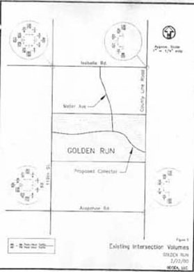
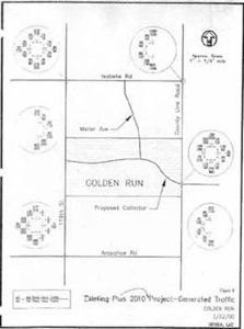
The location of the Golden Run development is shown in Figure 1. The site is within a single parcel of land adjacent to Erie and is located east of North 119th Street, west of County Line , and roughly halfway between Isabelle Road and Arapahoe Road.
Area Roadways
Major roadways in the vicinity of the site are described below with a brief discussion of anticipated future roadway improvements.
· North 119th Street is a north-south, two-lane roadway which is envisioned in 2020 as a two-lane minor arterial in the study completed by Felsburg, Holt & Ullevig (FHU) in July 1997. It is a principal north-south roadway in the Town of Erie located one mile west of County Line Road and Old Town Erie. It has a posted speed limit of 40 mph and is 22 feet in width. North 119th Street has a signalized intersection at Baseline Road (SH 7).
· Isabelle Road, also referred to in the Erie Comprehensive Plan as Leon Wurl Parkway, is an east-west roadway which is envisioned in the 2020 Town of Erie Transportation Plan as a principal arterial. Presently, it is a newly paved road as part of the Canyon Creek development upgrade to local roads. Leon Wurl Parkway connects US 287 with County Line Road. It has a posted speed limit of 40 mph west of 119th Street and 35 mph east of 119th Street. Its width is approximately 22 feet. In the remainder of this report, Isabelle Road will be referred to as Leon Wurl Parkway.
· Arapahoe Road is an east-west roadway, which is planned as a two-lane minor arterial in the 2020 Town of Erie Transportation Plan. West of its signalized intersection at US 287, it is designated as SR 7. It has a posted speed limit of 40 mph and a width of 22 feet. Its has continuity between East County Line Road on the east and the City of Boulder on the west.
· An additional analysis that was performed is the potential location of Golden Run's site access from County Line Road and the future alignment of Weld County Road 3 from the east. Golden Run is planning to align these streets if Weld County Road in fact intersects County Line Road across from Golden Run. We have used Barb, LLC's Traffic Impact Analysis to aid in determining the impacts on and of this future potential intersection.
Existing Traffic Conditions
Figure 2 shows existing volumes at the intersection of North 119th Street with Leon Wurl Parkway, 119th Street with Arapahoe Road, County Line Road with Leon Wurl Parkway, and County Line Road with Arapahoe Road. Noteworthy is a substantial flow of left-turning northbound to westbound traffic from North 119th Street to Arapahoe Road during the morning peak hour. Flow in the reverse direction is significant during the evening peak-hour.
Future Traffic Conditions
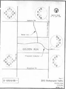
In order to have a basis for determining future traffic impacts, projections of future Year 2010 peak-hour traffic were made at the intersections of North 119th Street with Leon Wurl Parkway, North 119th Street with Arapahoe Road, County Line Road with Arapahoe Road, and County Line Road and with Leon Wurl Parkway, which are the primary intersections that will be affected by the Golden Run development. The year 2010 is used on the basis that it is the projected year for build-out, and is realistic in terms of forecasting. 2020 estimates were considered but determined to be unnecessary at this time due to the changing conditions of the regional development patterns.
Resultant peak-hour volumes for the Year 2010 are shown in Figure 3. These volumes constitute "background traffic," or traffic anticipated on the roadway system without consideration of the traffic generated by the proposed development.
Traffic Generation
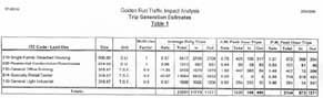
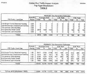
Golden Run is planned to consist of 790 single-family homes and 956,000 square feet of commercial space. Using traffic generation rates found in Trip Generation, 6th Edition, published by the Institute of Transportation Engineers in 1997, Table 1 and Table 2 have been compiled. These tables display the estimated average weekday traffic volumes and the morning and evening peak-hour traffic volumes expected to be generated by Golden Run.
Upon completion. the proposed development is estimated to generate approximately 23,551 vehicle-trips on an average weekday or about 11,776 vehicles entering and 11,777 vehicles exiting the site in a 24-hour period. During the AM peak-hour approximately 749 vehicles will enter and 486 vehicles will exit the site. During the PM peak-hour, there will be about 793 entering and 1,165 exiting vehicles.
Traffic Distribution
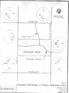
The geographical distribution of site-generated vehicular traffic on the roadways providing access to and from Golden Run is a key element in the planning of the project's specific access requirements and in determining its traffic impacts on surrounding roadways and intersections. Major factors which influence the traffic distribution include:
· The site's location relative to Old Town Erie and population centers in Boulder, Weld, and Adams Counties.
· The roadway network serving the area and region.
· The specific access and circulation characteristics of the development plan.
· The expected home-to-work and home-to-shopping travel patterns of the residents of Golden Run.
Considering the combined effects of these factors, specific traffic distribution estimates have been made. Figure 4 illustrates the directional distribution of traffic that will be expected by Golden Run.
Trip Assignment and Traffic Volumes
Site-Generated Traffic
Figure 5 illustrates the assignment of site-generated peak-hour traffic on the adjacent street system after the completion of construction. This assignment of generated traffic is based upon the traffic distribution percentages shown in Figure 4 and the vehicle-trip generation estimates of Table 1.
Background Traffic
As mentioned earlier in this report, the projections of future non-site-generated peak-hour traffic (i.e., background traffic) for the Year 2010 are shown in Figure 3. The background traffic volumes represent projections of traffic that would be on the street system if traffic generated by Golden Run were not included. Thus, they represent a "base condition" for measuring traffic impacts.
Total Traffic
Total peak-hour traffic volumes at the intersections of County Line Road and North 119th Street with Leon Wurl Parkway and Arapahoe Road, and the two site accesses are shown in Figure 6. These volumes were derived by adding site-generated traffic to the background traffic. Figure 6 shows site-generated traffic from Figure 5 added to 2010 traffic volumes on the existing network (from Figure 2).
Traffic Impacts
Traffic impacts associated with a development such as Golden Run are best described in terms of the resulting effects they have on the major intersections that serve the development. In this particular case, the expected impacts are concentrated on the four intersections of North 119th Street and County Line Road with Leon Wurl Parkway and Arapahoe Road, and the two site accesses.
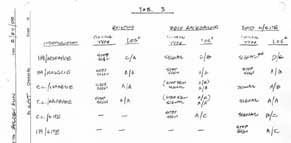
Based upon the peak-hour traffic volumes shown in Figures 2, 3, and 6, "Signalized and Unsignalized Intersection Capacity" analyses have been performed, using procedures set forth in the 1994 Highway Capacity Manual. The concept of Level of Service (LOS) is used as a basis for computing combinations of roadway operating conditions. By definition, six different levels of Service are used (A, B, C, D, E, and F) with "A" being a free-flow condition and "E" representing the "capacity" of a given intersection or traffic movement. Analyses have been performed for both the morning and evening peak-hour periods for existing traffic, existing traffic plus traffic generated by the proposed site, 2010 background traffic, and 2010 background plus site-generated traffic. The results of these capacity analyses are found in the Appendix B and are summarized in Table 3.
North 119th Street/Arapahoe Road: Presently, this intersection is stop-controlled along Arapahoe Road (at the east and west approaches). With project-generated traffic added to existing traffic, all approaches of this intersection will operate at a Level of Service LOS "D" with signalization timed/phased signalization.
North 119th Street/Leon Wurl Parkway: Presently, this intersection Is stop-controlled along Leon Wurl Parkway (at the east and west approaches). With project-generated traffic added to existing traffic, all approaches of this intersection will operate at a Level of Service "B" with the stop signs in place at this time.
119th Street/Site Access: At the 2010 projected build-out, this site access intersection will operate at a very good Level of Service "C".
County Line Road/Site Access: At the 2010 projected build-out, this site access intersection will operate at a very good Level of Service "C".
Recommendations
Based upon the State Highway Access Code, auxiliary lanes will be needed at both site access intersections.
Based upon estimated traffic volumes for the Year 2010, improvements will be needed at the intersections of North 119th Street with Arapahoe Road, and County Line Road with both Leon Wurl Parkway and Arapahoe Road. These improvements specifically include signalization at these three intersections.
Site access will also need improvements by the year 2010, in addition to the auxiliary lanes mentioned above, if not made during construction. Specifically, the access at County Line Road will need signalization.


Documents

Traffic Study

© 2013 by Golden Run Estates, LLC. and Aaron Harber. All rights reserved. “Golden Run” is a proprietary tradename. This document and its contents may not be reproduced, copied, conveyed, or transmitted, in whole or in part, without the express written consent of Golden Run. For such consent or for additional information, please contact Golden Run in care of Carl Oldham, General Manager, at Carl@GoldenRun.com. Thank you.