Welcome To The Golden Run Web Site —
Colorado’s Premier Multi-Generational Sustainable Community


Welcome To The Golden Run Web Site —
Colorado’s Premier Multi-Generational Sustainable Community
GOLDEN RUN
Annexation Drainage Report
Prepared by:
ODISEA
Engineering, Planning, Design
2814 15th St.
Boulder, CO 80304
Introduction
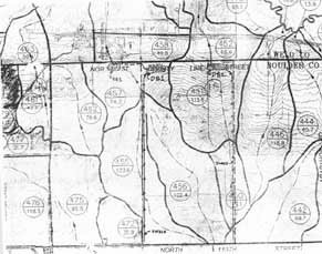
Golden Run is a proposed 330-acre mixed-use residential, commercial, civic-oriented community comprising the entire top half of Section 25, Township 1 North, Range 69 West. The entire property is located within the Coal Creek Drainage Basin and slopes from west to east at an average slope of approximately 2.5%. There are two main drainage tributaries that will influence the drainage patterns and future development of this property. The northern tributary is defined by drainage basins 455, 457 and 456 depicted on Figure A. The southern tributary is defined by basins 450 and 451. Interrupted only by County Line Road, these tributaries naturally outfall into Coal Creek approximately 3,500 feet to the east.
An irrigation and supply ditch lateral supplied with water by the South Boulder Cañon Ditch Company extends approximately 2,000 feet along the southern property line at the western end into the existing pond located centrally on the southern property line. The land is presently undeveloped corn fields with a small number of isolated buildings, including four residential properties.
Drainage Concept
The existing tributary drainage-ways will remain the primary drainage corridors for the development, intersected by swales on both the north and south property lines which will be used to direct runoff to the eastern end of the property into detention basins. The drainage concept proposed will eliminate the need for a buried storm-sewer facility. All drainage swales will be designed with low flow channels and will be analyzed for erosion and designed with erosion protection if necessary. Protection will be provided at each control structure within the development and will be integrated with the surrounding features. Storm-water detention will be provided for all developed areas. There will be two main detention basins at the eastern edge of the boundary that will outfall under County Line Road at historic flow levels as shown on the attached figure A. Drainage Basin DB1 will outfall along the western edge of County Line Road to the regional detention facility location identified as RB1 at the lower edge of basin 457 as shown on Figure A. The regional detention facility located at the outfall location under County Line Road within basin 457 this has not yet been established since a regional outfall report has not yet been finalized. However, preliminary feedback from Love and Associates, the regional outfall drainage consultants currently retained by the Town of Erie, suggests that this plan may be preferred by both the Town and Urban Drainage.
Offsite Tributary Drainage Basins
Offsite drainage historically occurs from both the north and south from drainage basins 455, 451 and 450 on to Golden Run, as shown on figure A. Drainage on to Golden Run from the north may be increased over historic levels due to the proposed Canyon Creek development. Canyon Creek had not developed a final drainage concept for their final platting at the time of Golden Run's annexation submittal and we can only assume that the proposed development will increase storm flows onto Golden Run along Meller Street. If this is the case, Golden Run intends to mitigate its impact on our development by accommodating the increased flows into oversized detention basins. Golden Run, however, should not be expected to incur increased costs due to neighboring development. It assumes the Town of Erie will enforce a regional policy of not allowing adverse impacts of development on surrounding properties. Historical outfall flows should be enforced, and Golden Run intends to conform to this policy with outfall along County Line Road into the regional facility RB1.
Community Ditch Lateral
The South Boulder Cañon Ditch lateral is generally located on a ridgeline running east along the southern property boundary. The lateral is not expected to collect and convey a significant amount of storm-water within Golden Run. In fact, Golden Run will propose burying the lateral within the NCWCD easement, or within an additional easement, along the southern property line. The lateral will not be used to convey developed storm runoff. The lateral capacity will be analyzed and controlled spill structures may be required to protect the development in the case of the line being buried.
Outfall Drainage Corridors
The outfall drainage corridors downstream from Golden Run to Coal Creek will be integrated with outfall planned for the property to the north and south as identified in the regional outfall plan now under development by the Town. These corridors will be analyzed for potential erosion and sedimentation problems. Erosion control and channel armoring may be required to protect these channels from longer more frequent stormwater runoff due to development.
As discussed above, outfall from basin DB1 will flow along the western border of County Line road to the regional facility RB1. The final elevation of RB1 and its outfall under County Line Road should be planned by the Town to accommodate Golden Run's need for adequate elevation drop. Outfall from DB2 will flow under County Line Road and will require raising the road to accommodate historical surface discharge or the purchase of a drainage easement on the Feuer Property. Should an easement be purchased, it would accommodate the possibility of a pedestrian underpass at this location. The outfall location shown on Figure A from DB2 also indicates a possible location for the intersection of othe internal collector and the extension of Weld County Road 3 from the east. This possibility is reflected on the Conceptual Plan included in the annexation submittal. If this possibility becomes reality, this will provide a logical outfall location along W.C.R. 3 to Coal Creek.
Erosion Control
Erosion protection and a stormwater management plan will be required during construction activities. Erosion bales, check structures, sediment traps and silt fencing will be used to control erosion during construction.
Hydrologic/Hydraulic Analysis
The level of analysis for an annexation proposal should be performed at such a level as to provide conceptual ideas while allowing flexibility for future infrastructure improvements. Figure 1 outlines the conceptual detention plan as shown on Figure A for detention at Golden Run. Table 2 outlines alternate detention facilities that were presented to the Town by Love and Associates. The drainage ponds 6, 7 and 10 are the only pertinent facilities for Golden Run's development. The facilities are addressed as DB1, DB2 and RB1, respectively on Figure A. Depending on the final regional outfall plan accepted by The Town, Golden Run intends to conform the recommendations contained therein. The present drainage concept addresses this conformity by locating detention ponds in close proximity to the ponds shown on the preliminary outfall maps generated by Love.
Figure 1
GOLDEN RUN
(Preliminary Drainage Design)
1. Drainage Basin Plan Areas:
Basin Designation Basin Area (acres)
450 42.1
451 113.6
455 123.6
456 122.4
457 24.8 (tributary to Golden Run only)
2. Detention Basin Sizes (approximate)
Pond Designation (trib. basins) Pond Size (acre-ft) 1
DB1 (450,451) 15.6
DB2 (455, 456, 457) 27.1
1 assumes Golden Run will accommodate all historical outfall from neighboring properties. If outfall onto Golden Run is increased due to development on the properties to the north and south, these facilities will need to be increased in size.
3. Allowable Site Pond Outfalls @ 1cfs/acre:
North Basin: DB1 (455, 456, 457) = 270.8 cfs
North Basin Outfall, Q100 = 270.8 cfs (Use 6x4 ft box culvert)
South Basin: DB2 (450, 451) = 155.7 cfs
South Basin Outfall, Q100 = 155.7 cfs (Use 6x4 ft box culvert)

Documents

Drainage Study

© 2013 by Golden Run Estates, LLC. and Aaron Harber. All rights reserved. “Golden Run” is a proprietary tradename. This document and its contents may not be reproduced, copied, conveyed, or transmitted, in whole or in part, without the express written consent of Golden Run. For such consent or for additional information, please contact Golden Run in care of Carl Oldham, General Manager, at Carl@GoldenRun.com. Thank you.